

Real Ale Rambles
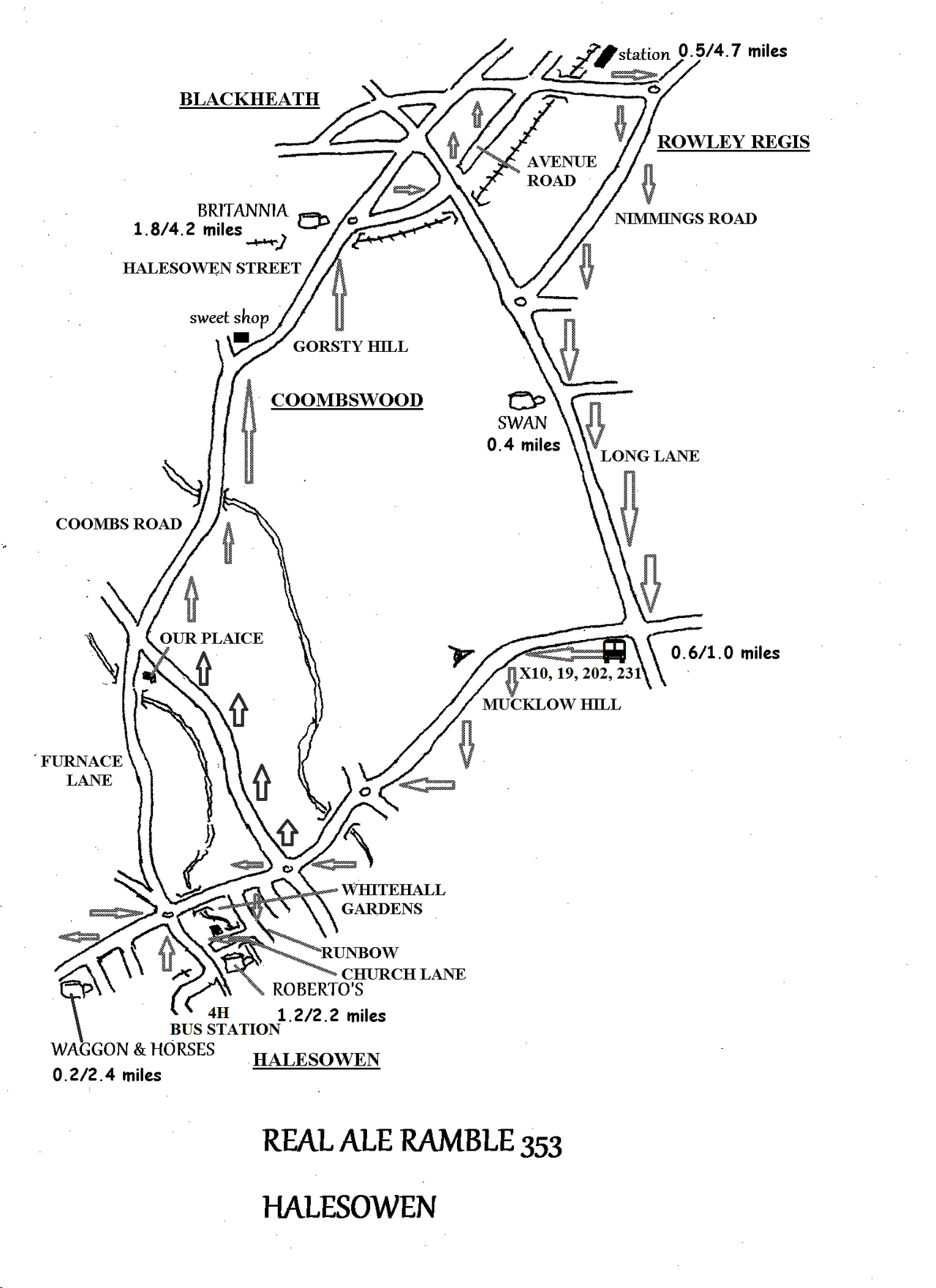
REAL ALE RAMBLE 353 Saturday February 14th
HALESOWEN 4.7 miles & 4 Pubs
We have a grand day our planned this time. I don’t believe we have ever had a trip to Halesowen before and although I tend to think of it as an outer suburb of Birmingham, or a part of the Black Country, it is in fact a pleasant market town near the Clent Hills. My immediate reason for planning a trip to Halesowen is Roberto’s Bar. Roberto Ross frequently hosts beer tastings at Gonzo in Earlsdon, so when I learnt that he has a bar in Halesowen, which is in the Good Beer Guide, I had to check it out! There are in fact four GBG pubs on this trip to try.
So, we catch the 11.06 train from Coventry which arrives in Birmingham New Street at 11.27. Then we have to walk to Moor Street to catch the 11.41 which gets into Rowley Regis at 12.02. After that a short walk along Nimmings Road and Long Lane will bring us to the SWAN shortly after opening.
We spend half an hour here before continuing for another half a mile along Long Lane to the crossroads at the Stag and Three Horseshoes, a sizzler pub so not on our itinerary. Here we can catch any of the buses that pass as they all go to Halesowen. The X10 passes every 20 minutes at 00/20/40 past the hour. If we alight at Shenstone roundabout there is as pleasant stroll into the town centre. We walk down a road with the odd name of ‘Rumbow’. Here we turn right into Church Lane, a charming lane which crosses a stream and passes cottages whilst climbing up to the church and High Street. Here stands ROBERTO’S BAR in a modern shop premises.
We can spend half an hour here before taking a short walk to the WAGGON AND HORSES on Stourbridge Road, a Black Country Ales pub. After half an hour we walk back to Halesowen bus station.
We catch the 4H bus which also departs every twenty minutes, at 10/30/50 minutes past the hour. This follows Dudley Road and then Coombs Road to Blackheath. It passes Our Plaice fish and chip shop and then a sweet shop, worth noting for future reference. As it approaches Blackheath we come to the BRITANNIA, a Wetherspoons pub. This has quite an attractive exterior which remains as it was previously a pub before becoming part of Wetherspoons estate.
After half an hour here we walk another half a mile back to Rowley Regis station where return trains run four times an hour
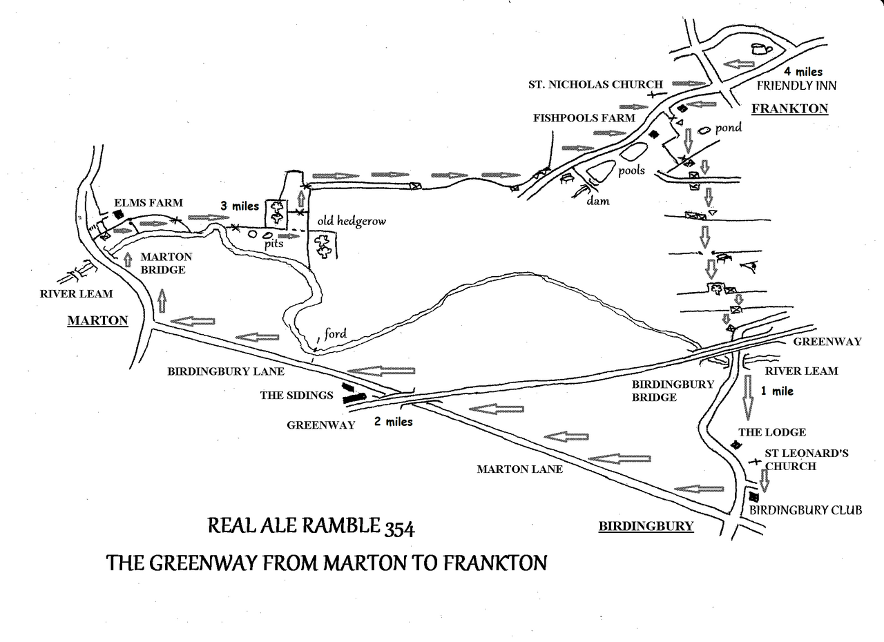
REAL ALE RAMBLE 354 Saturday March 14th
THE GREENWAY FROM MARTON TO FRANKTON 4.0 miles, 1 pub & 1 club (if its open!)
----------------------------------------------------------------------------------------
COMMENTS: There are some stiles on this walk. They are quite high so you will need to be reasonably agile to cross them!
________________________________________________________________________________
Some walks can lift your heart and reassure you that all is right in the world. Despite it being a muggy, rainy, misty day when I surveyed this walk in January this turned out to be one such walk. Now less of the hyperbole and on with the walk.
We meet at the FRIENDLY INN IN Frankton at 12 noon and set off at 12.30 to walk that part of the Greenway that does not follow the old railway line. Between Marton and Frankton. The railway is thickly overgrown with trees and shrubs that have not been cleared, so here cyclists and walkers have to take to the road that goes via Birdingbury to connect the useable sections. In order to create a circular walk I have incorporated a path that follows the north bank of the river Leam. So, from the Friendly Inn we walk westwards through the village as far as the church of St. Nicholas. Here we enter fields and go southwards. At a bench we get expansive views over the river Leam valley and the south Warwickshire hills beyond. We walk down the hill and come to the point where the road, old railway (Greenway) and river coincide. Since we cannot follow the Greenway to Marton we take the road towards Birdingbury. This lane has a verge that can be walked.
In Birdingbury we pass the charming little church of St. Leonard and then BIRDINGBURY CLUB where we may be able to stop for refreshment, if it is open. We shall see! At Birdingbury crossroads we turn right towards Marton. We pass under the Greenway at The Sidings. This is the other end of the useable section. We continue along the lane into Marton, where we turn right and cross the bridge over the river Leam. Just beyond the bridge there is a flight of steps leading down to a path which turns back towards the river. Crossing a stile we go left and follow the river upstream. Across a second field we come to a new stile. Over this takes us into the next field, where we skirt a meander in the river and cross another stile. Now we follow the hedge on the left through an uneven area, maybe old clay pits from the look of the earth here.
This field has become a large L-shaped one with the removal of a hedgerow, evidence of which is shown by the remnants crossing the field in a line. It was in this field that I saw a roe deer doe, rabbits and jays. Then I was followed along the hedgerow by a group of blue tits. I dunno you don’t see any wildlife for ages and then they all come along at once. This was the heart lifting bit.
We go left and pass between woodland on both sides and then go over an electric fence by the kind of stile you get on these barriers We follow the right hand hedge to a stile. Over here there is a track bounded by a hedge on the right and electric fence on the left. At the end of the track we go through a gate into our last field.
Following the hedge on our right we come to a gate and stile that gives access to a metalled lane. We follow this past fishponds created with ancient dams. Then we pass Fishponds Farm and return to St. Nicholas church. It is a short walk retracing our steps back to the FRIENDLY INN.
FUTURE EXPEDITIONS
All meeting times are 12 noon, unless specified otherwise.
These details are also available at in the ECHO newspaper and at https://coventry.camra.org.uk/viewnode.php?id=57922
April 18 SHIPSTON ON STOUR
The Ramblers’ weekend is in Shipton on Stour this year
Meet at the George in the Market Square at 12 noon for a walk around the town.
May 16 HENLEY TO ULLENHALL
June NAPTON
July WARWICKSHIRE LAD
June NAPTON
July WARWICKSHIRE LAD
Aug GREENWAY AROUND FRANKTON
SUNDAY LUNCH WALKS
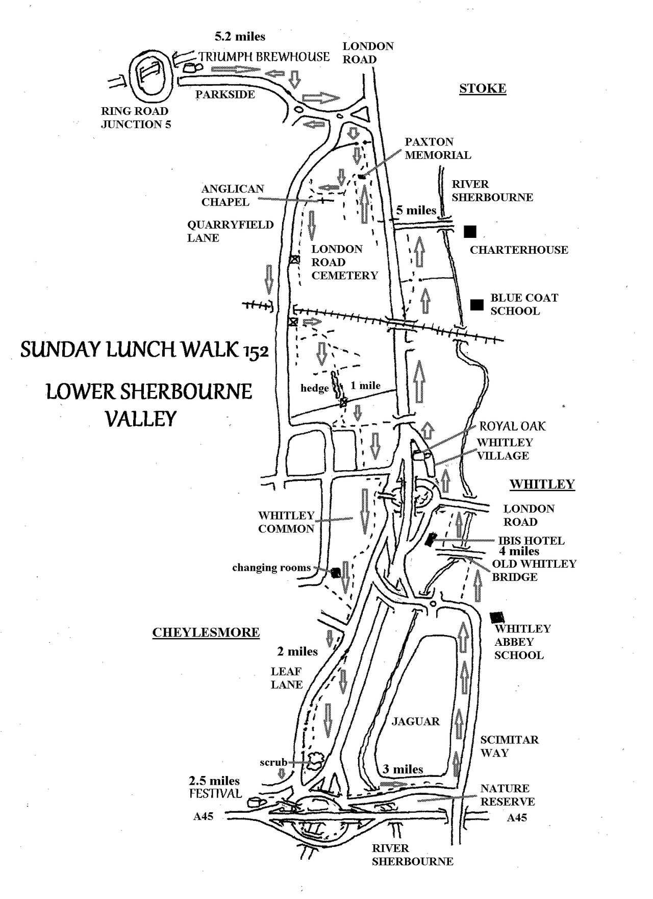
SUNDAY LUNCH WALK 152 Sunday Feb 1st
LOWER SHERBOURNE VALLEY 5.2 miles & 3 pubs
I have long thought that it should be possible to walk south along the west side of the Sherbourne valley out of town then back north along the east side. Since the Triumph Brewhouse opened this seemed a walk that could start there. Yet this was not possible because Whitley Aerodrome, now Jaguar Land Rover, and the A45 stood in the way. Since the JLR site and its associated industrial estate have been redeveloped and with the move to encourage cycling or walking to work, access around the area has improved; especially with the creation of Scimitar Way. So here is the resulting walk.
We meet at the TRIUMPH BREWHOUSE in Parkside at 12 noon and set off walking at 12.30. We walk to the London Road cemetery and go past Paxton’s memorial and the Anglican chapel to reach Quarryfield Lane. This takes us over the railway line to the southern section of the cemetery, which we walk through to reach Whitley Common. We follow the eastern edge of the common, alongside the dual carriageway until we come to the southernmost corner. Now we follow Leaf lane until we come to a gap in the hedge on the opposite side of the lane, alongside a sign telling us that Coventry City Council allows pedestrians to walk these fields. Nice of them to tell us!
We enter the fields and follow the hedges on the right separating the fields from Leaf Lane, until we come to a scrubby area. Here the Path turns right and rejoins Leaf Lane. The path on the right hand side of the lane leads to the FESTIVAL pub after 2.5 miles. We can rest here for half an hour.
Leaving the Festival we take the rather circuitous route around the A45 junction, eventually emerging onto Scimitar Way. Thus takes us over the River Sherbourne and around the JLR site. As we pass Whitley Abbey School and approach the dual carriageway again there is a straight track through woodland on our right. This takes us to the old bridge at Whitley, where the original London Road use to cross the Sherbourne, which was replaced by a new bridge a few hundred yards upstream when the toll road was built in the eighteenth century.
We cross the bridge and then walk between the river and the Ibis Hotel to the junction on the London Road. We now negotiate this roundabout which this time involves a crossing of the busy road on the level without any traffic lights. Do be careful! After this we walk through Whitley Village to the ROYAL OAK. We stay here for half an hour before setting off again. Now we follow London Road under the railway bridge before turning right into Charterhouse Fields, with views of Blue Coat School and then the Charterhouse across the river. Teddy and I saw a little egret here when we surveyed the walk. At the end of the fields we cross London Road and re-enter the cemetery for a short while and take the short walk along Parkside back to the TRIUMPH BREWHOUSE
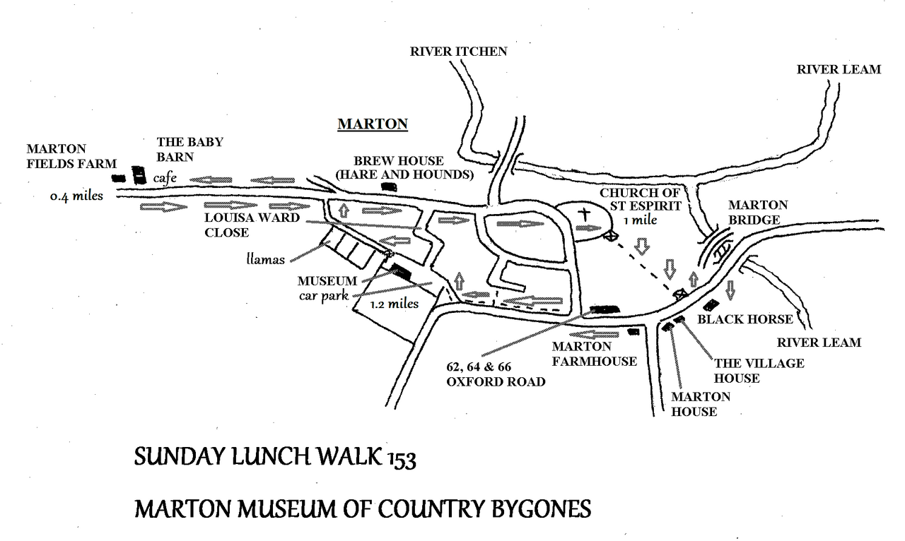
SUNDAY LUNCH WALK 153 Sunday March 1st
MARTON MUSEUM OF COUNTRY BYGONES 1.2 miles
Following our visit to Chedham’s Yard in September I thought it was time to visit the museum at Marton. This was originally in farm outbuildings where the new housing estate now stands. When the estate was built the collection was moved to an unprepossessing new building by the village playing field.
Marton is an ancient village at the confluence of the rivers Itchen and Leam, which in late Anglo Saxon times was the centre of an administrative area known as a ‘hundred’. We will have a walk around the village before visiting the museum. We meet at the museum at 12 noon and half an hour later move off for our walk around the village. We set off along a path that passes small fields which at various times contain sheep, pigs and llamas. When we come to a road we turn left and walk out to Marston Moor, an area of large fields on reclaimed farmland. When we reach Marton Moor Farm we come to the cafe which is attached to the ‘Baby Barn’, a baby goods shop. Both are closed on a Sunday, so you won’t be able to purchase a cake, nor a coffee, nor a baby.
Here we turn around and walk back through the village. We pass ‘Brew House’, which I remember being the Hare and Hounds pub until the 1980’s. As we pass through the village it seems that most of the buildings are old enough to deserve listing, so I’ll just mention a few of them.
First is the church of St. Espirit, that is the Holy Spirit, which originated at an early date, being a ‘hundredal’ church that was a missionary centre for Marton hundred. The present stone church dates from 1160. The church may be open so we can see inside. It has a small floor area, but is relatively tall, reminding me of other early churches I have visited. From the churchyard a path leads to the main road opposite the old Black Horse pub, which became an Indian restaurant some years ago and is now closed.
A few yards from here stands the old Marton bridge which spans the River Leam. This was built in the medieval period, but archaeologists can trace nine different stages of construction! The importance of bridges is shown by the fact that they are often the oldest structures in a landscape, after churches that is!
We turn back into the village to a group of listed buildings, all of a similar date, at a junction. First is ‘Village House’, dating from the late 18th century. Next to this is ‘Marton House’, originally one house but now divided into two, again of 18th century date. On the opposite corner is ‘Marton Farmhouse’. This dates from the early 18th century Stuart period. Opposite the junction stands a row of cottages, Nos 62, 64 and 66 Oxford Road. These are timber framed with rendered and whitewashed brick infill. All three cottages are thatched and date from the 18th century. They have eyebrow windows in the first floor. As I remarked earlier, most of the village looks as though it could be listed!
We continue south along Oxford Road until we come to a path leading back to the playing fields, which we should reach at around 1.30. Here we meet David Fry, a resident of the village and historian, who is responsible for the museum. He will open up and no doubt be most informative about the exhibits.
After our tour, whenever that is, I shall be providing the country lunch of bread and cheese at the village field, for anyone who wants to stay for a snack. Let’s hope the weather is kind!
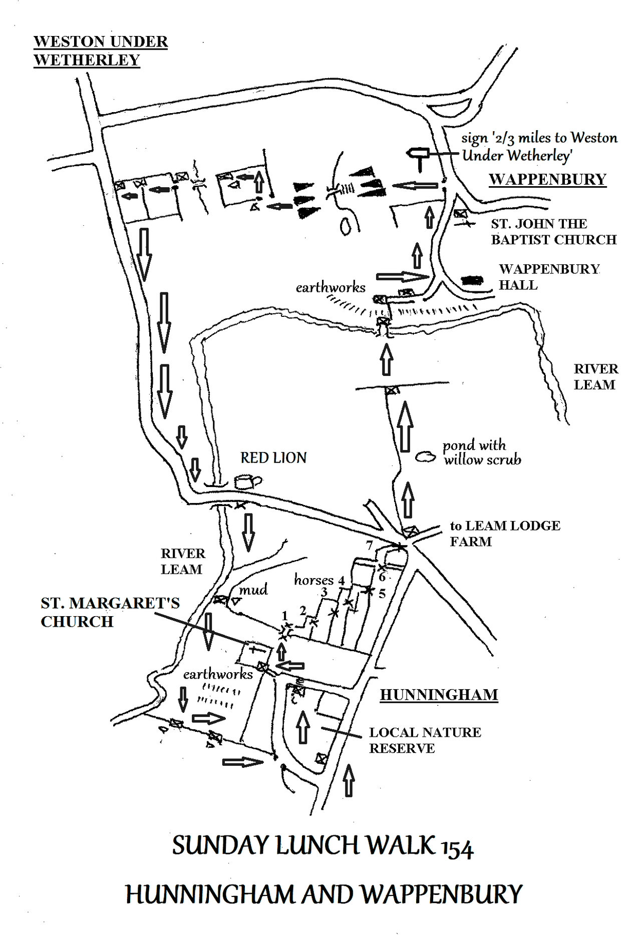
SUNDAY LUNCH WALK 154 Sunday April 5th
HUNNINGHAM AND WAPPENBURY 3.2 miles and 1 pub
------------------------------------------------------------------------------------------
COMMENTS: There are lots of stiles on this walk, so you need to be a little agile. Mud is also possible.
__________________________________________________________________________________
Given the warning above, there is a good side to this walk in that it is short and we visit two charming villages on the River Leam. With all the modern concerns on over population it is easy to forget that the countryside had the opposite problem over the last couple of centuries. The countryside was de-populated thanks to the agricultural revolution and mechanisation. Today Hunningham is a sparsely populated village whilst Wappenbury is no more than a hamlet.
We meet at 12 noon at the RED LION with its extensive lawns alongside Hunningham Bridge on the river Leam. At 12.30 we set off across the road to our first stile. Over here we walk through a riverside meadow. The path then becomes enclosed between hedge and river: here is a muddy stretch. Soon we go through a gate into a larger meadow. Here we get a view of St. Margaret’s church with its odd wooden tower on a hill to the left. There are earthworks in this field, probably remains of the larger ancient village. At the end of this field we go left and through a gate. Following the hedge on our left we emerge onto a village lane. Here we go right, then left at a road junction and through a gate on the left to enter a field between a triangle of lanes.
This is the village nature reserve. The grass is kept close cropped by grazing, but no doubt it is untouched by herbicides or fertilizer, so nature is being given a chance.
At the end of this field we turn left along a lane to the church and a little group of cottages. At the church we take a path on the right. This passes a footbridge over a tributary stream of the Leam. After this there is an area that has been divided into multiple small horse paddocks. Each paddock has a wooden stile as you enter and leave, so there are seven stiles to negotiate before reaching another road. Fortunately each poaddock is only 19 – 20 yards wide, so the next stile is always obvious and negotiating this complex area is quite simple.
At the end of this we emerge on a road at a junction of routes. We pass through a gate between the road to Leam Lodge Farm and the rear access to cottages. Now we follow the left hand hedge through a large field with views of Hunningham Hall ahead. This was the home of Sir William Lyons, the founder of Jaguar Cars from 1937 until his death in 1985. At the end of this field we go through a gate and continue straight down to the river where a quaint footbridge takes us towards Wappenbury.
After the footbridge we walk uphill past the earthworks associated with the bury at Wappenbury. This name commemorates and Anglo Saxon man Wappa and his bury, a bury being a fortified place or settlement. This is an anachronism as it is an Iron Age fort or camp, similar to that at Corley Rocks and similarly an embanked enclosure. It doesn’t appear to be a defensible site such as Maiden castle or Uffington castle.
We walk through the village of scattered houses, more a hamlet these days and pass the church of St5 John the Baptist. Shortly after this a path is signposted as 2.3 mile to Weston Under Wetherley. We go through a gap in the hedge here and through a large field which eventually drops down a steep slope to a footbridge over a stream. Then up the slope on the other side we come to a gap in a hedge. Through here we follow the field edge to a gate in the opposite corner. Then over another footbridge we follow the right hand hedge and go through two gates before reaching the lane near Weston. Here we turn left and follow the lane, which has a broad verge, back to Hunningham Bridge and the RED LION.
FUTURE EXPEDITIONS
These walks all start at 12 noon, unless stated otherwise..
These details are also available in ECHO newspaper and at https://coventry.camra.org.uk/viewnode.php?id=57922
Sunday May 3 BINLEY WOODS – Four cafes
Sunday May 31 BERMUDA LAKE, MOUNT BERMUDA & VILLAGE GREEN
Sunday July BURTON FARM, WOLVEY – fishery, swimming lake, cafe
ARCHIVE (from October 2024 onwards)
REAL ALE RAMBLE 337 Saturday October 26
BIRMINGHAM WEST 2 miles & 4 pubs
For some while now I have wanted to travel the Metro west, in the opposite direction to the original line, which we have explored in the past. Now that the Metro reaches Edgbaston it is time to do this. The terminus is now ‘Edgbaston Village’, which sounds almost as ridiculous as ‘Earlsdon Village’, however there musty be a grain of truth in both terms, as both Edgbaston and Earlsdon were presumable separate villages once.
I realize that some people will say that I have missed a trick by not doing the Stirchley Mile, but I will do this in the new year. As it is I intend to get the metro to Edgbaston and visit three Good Beer Guide pubs on the way back into Birmingham. Certainly Edgbaston is an attractive leafy suburb with white painted stucco houses.
I aim to catch the 11.15 train from Coventry which arrives at Birmingham New Street at 11.44. At New Street I shall catch the tram to the terminus at Edgbaston and then walk down Highfield Road to the PHYSICIAN for shortly after 12.00.
At 12.30 we set off walking through the leafy roads, rather than going via Fiveways. We turn right into Greenfield Crescent, an attractive arc of houses many of which have been turned into bars. Here is LOKI BAR, part of the chain of wine bars that also have a premises in Knowle. I still have my card from the last time we went to Knowle, so I shall pop in, see how much is left on mu card, and have a glass or two of wine.
From there we follow St James’ Lane and pass the pretty garden of George Cadbury’s House. We cross the canal here, but there is no away down to the towpath, so we have to go to Fiveways Station to obtain access. Then we follow the canal for a short distance to Granville Street in order to reach the CRAVEN ARMS.
After the Craven Arms we can cross the dual carriageway at the pagoda roundabout into the city centre and walk up to the POST OFFICE VAULTS. Then people can go freestyle and visit anywhere they wish, though I have a curiosity to see the new Wetherspoon’s, the LONDON AND GREAT WESTERN before catching a return train.

SUNDAY LUNCH WALK 137 Sunday Nov 3rd
BEATING THE BOUNDS OF EARLSDON 5 miles & 2 pubs
This month’s walk come courtesy of Earlsdon Online’s Earlsdon Parish Boundary Walk, with a couple of minor alterations.
We meet at the CITY ARMS in Earlsdon at 12 noon and set off at 12.30 along Earlsdon Avenue North. We walk up to the traffic lights on Hearsall lane and enter Hearsall Common. Then we follow the length of the Common through woodland before turning south to reach Broad Lane. We follow the western edge of the Common past the Hore Well and the site of the lost village of Horewell, which is still with us today in the name ‘Hearsall’, which is a corruption of ‘Horewell’.
We come to Canley Road and cross the railway by Canley Station, continuing to Fletchamstead Highway. Here we cross the dual carriageway to the PHANTOM COACH for half an hour’s rest and relaxation at the half way point.
After this we walk down to the pedestrian crossing to cross the road and enter Canley Ford. He we cross Canley Brook and walk along the lane to Kenilworth Road. Across this road we pass through Stivichale Common to enter the War Memorial Park. We pass Coat of Arms Bridge and follow the edge of the park northwards. Then we pass the War Memorial and recross Kenilworth Road to go through Top Green. From there we cross Spencer Road and go through Spencer park to reach Albany Road, which brings us back to the CITY ARMS.

REAL ALE RAMBLE 338 Saturday November 16th
LONG ITCHINGTON GREENWAY SOUTH 2 miles & 1 pub
Some of you will remember that we walked the greenway north a year or two ago. Well now we will follow the greenway in the opposite direction, south towards the village of Long Itchington.
We meet at the GREEN MAN at 12 noon as we know that this pub was open on a Saturday lunchtime the last time we were here.. At 12.30 we set off along the lane, over the River Itchen to reach the greenway. At the bridge we go south-east and after a few hundred yards the greenway bridges the canal and then the river. The greenway peters out here at an overgrown cutting so after looking down at the river we have to turn back to the canal.
Following the canal we get views of the church and village through the trees. Then at bridge 25 the main road crosses the canal. Here we go through a gate into a field. Through gates and across a track we come to a footbridge over a stream. Then across another field we come to a track that takes us back to the village near the pond and a rather fine modern war memorial. We turn left here and go through the churchyard of Holy Trinity Church. Past the Co-operative store we return to the GREEN MAN. Other pubs are available in Long Itchington!

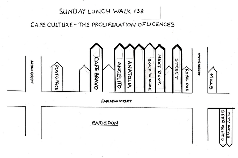
SUNDAY LUNCH WALK 138 Sunday Dec 1st
EARLSDON STREET 100 yards & 4-6 cafes
Well, Christmas is on its way, so its time to start the festivities with our annual Earlsdon Street cafe crawl again. This started some years ago as a way of highlighting the proliferation of alcohol licences on the high street and has become a bit of a tradition now. People are welcome to join us for a chat and a drink and then depart again as they wish.
We meet at 12 noon at CAFE BRAVO. After half an hour or so we move on to ANGELITO and then ANATOLIA., which are next door to each other.
Then we have to walk past a couple of shops before coming to SURF AND SLICE and NEXT DOOR, which again are next to each other. They are both owned by the same management and it is possible that Next Door will not be open on a Sunday afternoon. We shall see.
After this we have to pass more shops before coming to STREET, which again may not be open on a Sunday afternoon, so again we shall find out. After this people can decide whether to return home or end at one of the more conventionally ‘pubby’ premises such as the Royal Oak, Mills’s, Beer Gonzo or the City Arms.
See you at Cafe Bravo
Fred and Sharon
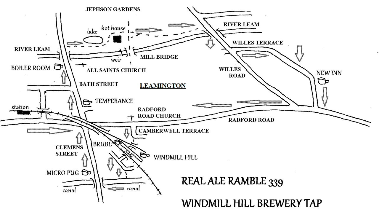
REAL ALE RAMBLE 339 Saturday December 14th
WINDMILL HILL BREWERY TAP, LEAMINGTON 3 miles & 6 pubs
This month we are off to Leamington again, after a gap of around a year, this time to visit the Windmill Hill Brewery Tap, amongst others. I shall be catching the 12 noon train from Coventry Station, which arrives in Leamington at 12.16. Other forms of transport are available but I prefer 15 minutes on a train to over the Ho Chi Minh Trail by bus! I should get to TEMPERANCE bar around 12.30. Here we will have to drink a bottle or something like that as they don’t do real ale.
Then we move on to the BOILER ROOM before a gentle stroll through Jephson Gardens, where we can pop into the hot house to see the exotic plants. We emerge onto Willes Road and then Willes Terrace takes us to the NEW INN, which is in the 2025 Good Beer Guide, after an absence of many years. It will be interesting to visit the old pub again.
After this we walk back into town along Radford Road. When we reach the Radford Road Church we turn left into Camberwell Terrace. Straight on here under a railway viaduct takes us to the industrial units in the arches that are home to both BRUBL and WINDMILL HILL.
Brubl opens at 1.00 p.m. but Windmill Hill not until 2.30, so I guess it will be Brubl first!
After Windmill Hill we pass under the next railway viaduct, turn left and come to the canal. We go right here and along the towpath to the next bridge. Here we leave the canal and cross Clemens Street to the MICRO PUG, which was previously ‘Procaffinate’. I note that Clemens Street contains a Greek restaurant, a Greek cafe and a Portuguese grocers cum bakery. Yummy.
After leaving Micro Pug we return to the station for the next train home.
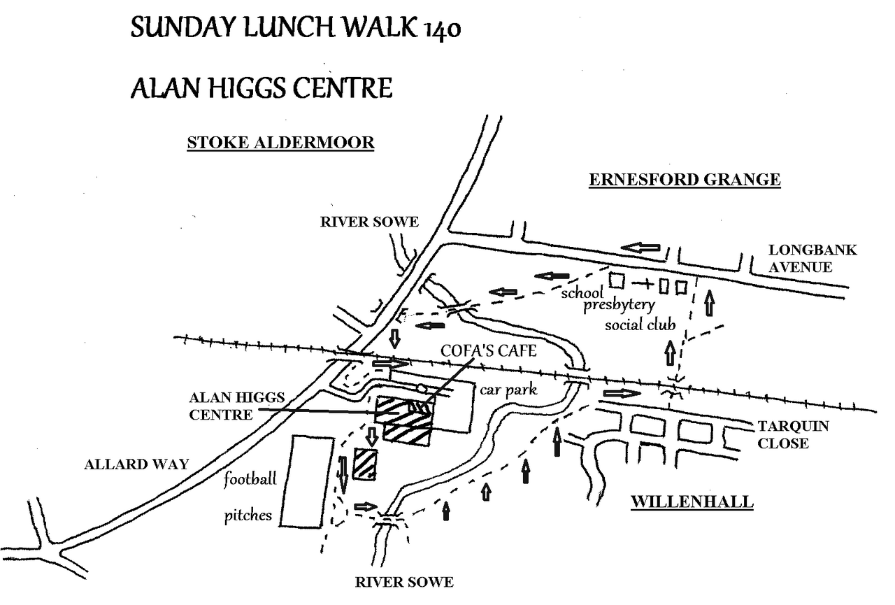
SUNDAY LUNCH WALK 140 Sunday February 2nd
ALAN HIGGS CENTRE 2 miles & 1 cafe
I was unaware of the footbridge over the River Sowe here until my grand daughter pointed it out a couple of years ago. I have finally got around to organising a walk over it now.
We meet at 12 noon at COFA’S CAFE, part of the Alan Higgs Centre. In the last couple of years this cafe has moved within the building and become substantially bigger. Although dogs are not allowed inside, there are picnic tables outside, so it is possible that Teddy may be with us!
At 12.30 we set off past the football pitches. Towards the end of the pitches the path veers left down to the footbridge over the river. Over the bridge we go left and walk across the grassy meadows between the rivers and Willenhall. The path here was flooded in December, so I will have to go and check it out before we do the walk. Lets hope its not flooded in February.
Eventually we come to Tarquin Close. From there we go under the railway line and reach Langbank Avenue. Going left along the Avenue we pass a Social Club, Presbytery, church and school, all part of the Corpus Christi complex. The we join a path alongside the river and cross it by bridge again. Next we follow Allard Way under the railway and back to the Alan Higgs Centre for COFA’S CAFE again.
REAL ALE RAMBLE 341 Saturday February 22nd
STIRCHLEY MILE 2 miles & 6 or 7 pubs
This month we are going to walk the Stirchley Mile. This is a walk that the Coventry Branch of CAMRA did more than a year ago, so I have quite shamelessly cribbed it! Although it is called the Stirchley Mile you will have walked 2 miles by the time that we have visited all the venues.
We meet at Coventry station and catch the 11.27 train which arrives at Birmingham New Street at 11.48, where we change to the 11.53 to Bromsgrove. We arrive at Kings Norton at 12.08 and turn left out of the station to the roundabout at Cotteridge. Here we come to a micropub called the RED BEEER’D.
After 30 minutes we leave to follow Pershore Road past Dell Street and into the Waterside Business Park, where we find the GLASSHOUSE BREWERY. There have been rumours that this has closed, but in fact the bar has been closed while all hands we occupied satisfying the Christmas demand. I have been assured that the bar will have re-opened by the time that we are there.
After this we continued along Pershore Road as far as Hazelwell Road. This takes us to Stirchley Trading Estate where BIRMINGHAM BREWERY is based, with a most attractive outdoor drinking area.
Again we continue along Pershore Road as far as the BRITISH OAK, a pub well known for its oak panelled rooms. Although not as elaborate as the Barton’s Arms, this is Grade II Listed. It is a relatively intact 1920’s roadhouse pub. The original suite of rooms have survived with their original seating, ceiling plasterwork, fireplaces, flooring, stained glass windows and wood panelling.
Across the main road there is another micro-pub, the CORK & CAGE. Then slightly south there is the WILDCAT brewery tap at 1381-1383 Pershore Road. I couldn’t find this on my survey, so perhaps it is closed mid-week. Lets hope we have better luck this time!
From here we continue south to Mary Vale Road and go uphill towards Bournville Station. ATTIC BREWERY BAR is just before the canal and railway bridge. When we finish here we can catch the next train to New Street. There are three an hour, so it shouldn’t take any planning.
SUNDAY LUNCH WALK 141 Sunday March 2nd
BALSALL COMMON HERITAGE TRAIL 7 miles & 3 pubs
COMMENTS: This walk can be muddy in places after rainfall.
This walk is one of the best ones we have done over the years: it is a long one, with lots of listed buildings, footpaths, fields and three pubs.
Balsall Common itself was a typical Arden settlement of scattered hamlets with no recognisable centre in the parish of Berkswell until recent times. This explains why the station and windmill are both still called Berkswell rather than Balsall. There are three cafes in the village, but because I have made this a Sunday walk, their restricted opening hours means that we cannot use them. I shall arrange a Saturday walk in the future to take them in.
We meet at the BRICKMAKERS ARMS at 12 noon. This is something of a change as we usually meet at the Railway, but this time I thought we could vary things a little! At 12.30 we set off towards the centre of the modern village. We soon come to the OLD VILLAGE STORE and on its left the old butcher’s shop with its abattoir. We then walk down Sunnyside Lane to SUNNYSIDE HOUSE, which was built in 1763 to replace an older house. We are now passing through the old hamlet of Oldnall End. Now we follow Barrett’s Lane and pass SUNNYSIDE FARMHOUSE, a listed timber framed house. Further along is POOL ORCHARD, an attractive old house with its own pool. This dated from the 17th century and has a sandstone base with timber frame.
We continue to follow the lane until it turns sharp left towards BARRETT’S LANE FARM. This is thought to have been built in 1570 on land owned by Berkswell Charities but can only be seen in the distance. Here we continue through fields until we come to a small field of medieval RIDGE AND FURROW. These do not stand out markedly today, but can be followed as the furrows are filled with reeds. The vegetation gives them away!
Next we pass the TINGSTED, said to have been a Viking meeting place, but I guess this is a recreation. From here we walk to Windmill Lane, passing the old POST OFFICE shop and the cottage that pre-dated it, with a post box embedded in its wall. Windmill Lane takes us to BERKSWELL WINDMILL. This is a stretch of lane without a path, so please be careful of traffic. The windmill was originally a post-mill dating from 1706 but is now a four-bladed tower mill. In 1927 the blades were halted and the mill wheels were turned by diesel engine until 1948. The mill was restored between 1973 and 1975 and it is now the best surviving example of a Warwickshire tower mill.
Just past the windmill a path cuts through to the main road, going through five successive gates. We have to cross the main road to use the path that follows that side. We walk back towards the centre of the village until we come to the drive to Harper Fields Care Home. We follow this until we come to a gate on the right, alongside the cottage that was John Sillett’s home until his death. That’s one for the football fans!
Here a path takes us in a broad curve, through boggy patches, to a farm track. We pass a derelict country house and cross Holly Lane into Frog Lane at COTTAGE FARM. This dates from 1744 and is built on a base of sandstone blocks. Further on we pass FROGMORE GRANGE, dating from the 17th century with additions in c1810. It was formerly called Balsall House, the official residence of the Squire of Balsall.
Frog Lane takes us to Balsall Street at the OLD FORGE. The forge, blacksmith’s cottage, sawmill and wheelwright’s shop were once the centre of life at this end of Balsall Common. It is at the forge that the Arden car was built, or should that be assembled, the only car ever to be built in Balsall Common. There is an example in Coventry’s Motor Museum.
COURT stands opposite, a former farm with barns. This was first recorded in 1736, when it was owned by Lady Katherine Leveson’s Charity of Temple Balsall. The thatched barn is a listed building.
We continue along Balsall Street and pass the entrance to Oakes Farm. Then we join a path on our left that skirts housing to reach Long Brook Lane and then Magpie Lane where we come to MAGPIE FARM, a black and white timber framed building, dating from 1560, with a central Elizabethan fireplace. It was formerly called Churchfield Farm. The next building is BALSALL OLD FARMHOUSE, a 17th century red brick building with some timber framing and a contemporary red brick chimney stack.
Next we can take a break at the SARACEN’S HEAD, which dates back to the 13th century, when the Knights Templar owned Temple Balsall and were fighting the Saracens in the Holy Land, although the main building is Elizabethan and later still it was a coaching inn.
After 30 minutes rest we continue and pass TEMPLARS’ COTTAGE, which was built in the 15th century and was three labourers’ tenements before being converted into a single dwelling in 1948. At the end of the row of houses here we start the real country section of this walk by passing through a gap in the roadside hedge opposite. Here we walk through typical Warwickshire countryside of fields, hedges, trees and ponds, before passing the frontage of WOOTTON GRANGE, a Victorian edifice that has now been split into five different houses. Through more fields, with a stand of conifers to our right as a landmark, we come to Wootton Lane, where we go right and walk through another old hamlet called WOOTTON GREEN. We pass WOOTTON GREEN FARM and then BLYTH PRIOR, a little timber-framed cottage with whitewashed brickwork, thought to date to the 1600’s. I admired this chocolate-box cottage when I delivered the post here and, what do you know, its for sale!
Back on the main road we pass Old Lodge Farm Antique Centre before coming to the GEORGE IN THE TREE. This dates from at least the 18th century. It took its name from the four Hanoverian Kings called George and, as it stands back from the road, its sign hung from a large roadside elm so it became the ‘George in the Tree’. It stood on the drovers’ route from Wales to London and the drovers would enclose their animals in the grounds overnight. Today people are enclosed here as it is now the site of a Premier Inn, so I guess it is more a hotel bar than a pub, but we shall see. Here we can take another 30 minutes rest before continuing our expedition.
From the George we cross the road and walk through playing fields. Then across more roads we join the woodland path that leads to LAVENDER HALL FISHERY. The cafe here closed at 1 p.m. I am afraid, but we can look at the pools and the HS2 works and I will organise that walk to the cafes of Balsall for a few months time. Now we soon return to the BRICKMAKERS ARMS to finish the day.
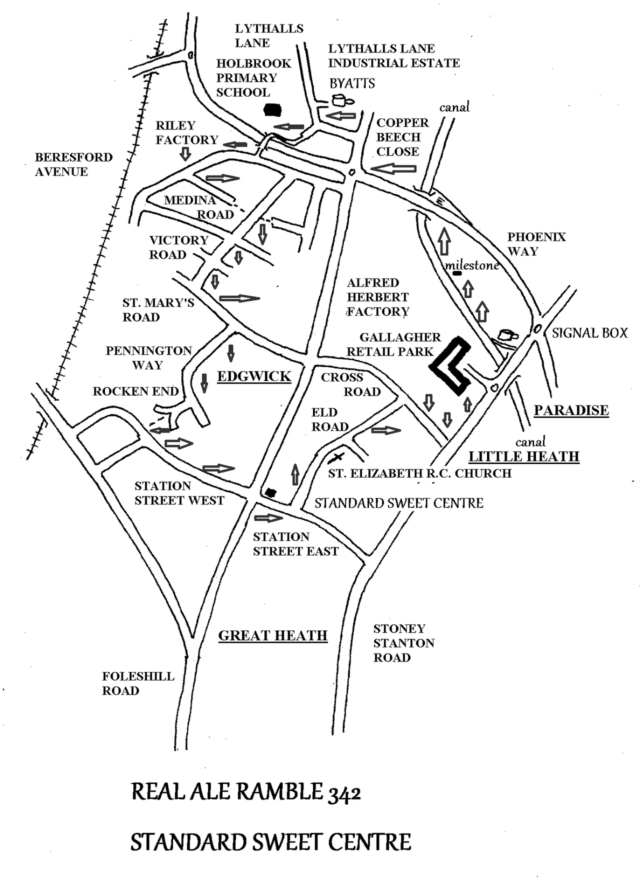
REAL ALE RAMBLE 342 Saturday March 15th
STANDARD SWEET CENTRE 3 miles, 2 pubs and 1 Indian Cafe
This month we are going to explore the back streets of Foleshill. Not the most scenic of walks and there is plenty of rubbish scattered around, but there are also some fascinating sights, industrial archaeology and parts of the city we don’t usually visit.
We meet at 12noon at BYATT’S BREWERY in Lythall’s Lane Industrial Estate. At 12.30 we set off along Lythall’s Lane towards Foleshill Road. At the corner we find Copper Beech Close on our right. Past a couple of houses we follow the close as it becomes a path. It passes the old Dunlop sports field and Holbrook Primary School, and then takes a bridge over Phoenix Way to Beresford Avenue. We turn right and on the right side of the road is an industrial area, once the site of the Riley car factory.
We turn left into Medina Road, then Victory Road and St. Mary’s Road. Pennington Way is next and where Rocken End starts we find a path that takes us to Station Street West. Left along here we pass the old Angel Inn, now a Punjabi Vegetarian Restaurant: now there’s a possible future walk!
We soon come to the STANDARD SWEET CENTRE on the crossroads at Foleshill Road, where we can indulge in spicy snacks or sweet confections.
After half an hour we move on along Eld Road. We pass St. Elizabeth’s Roman Catholic Church and turn right into Cross Road. We walk past Gallagher Retail Park on the site of Alfred Herbert’s factory. Soon we have the opportunity of another break at the SIGNAL BOX.
Another 30 minutes later we join the canal towpath and walk parallel to the old Alfred Herbert’s site on the opposite bank. At one point we pass an old milestone with 3 and 2 on its faces. I guess that is 3 miles from Coventry basin and 2 miles to Hawkesbury Junction. Opposite is a view through the factory site to Cross Road. Soon we join Phoenix way and walk back to Lythall’s Lane to return to BYATTS again.
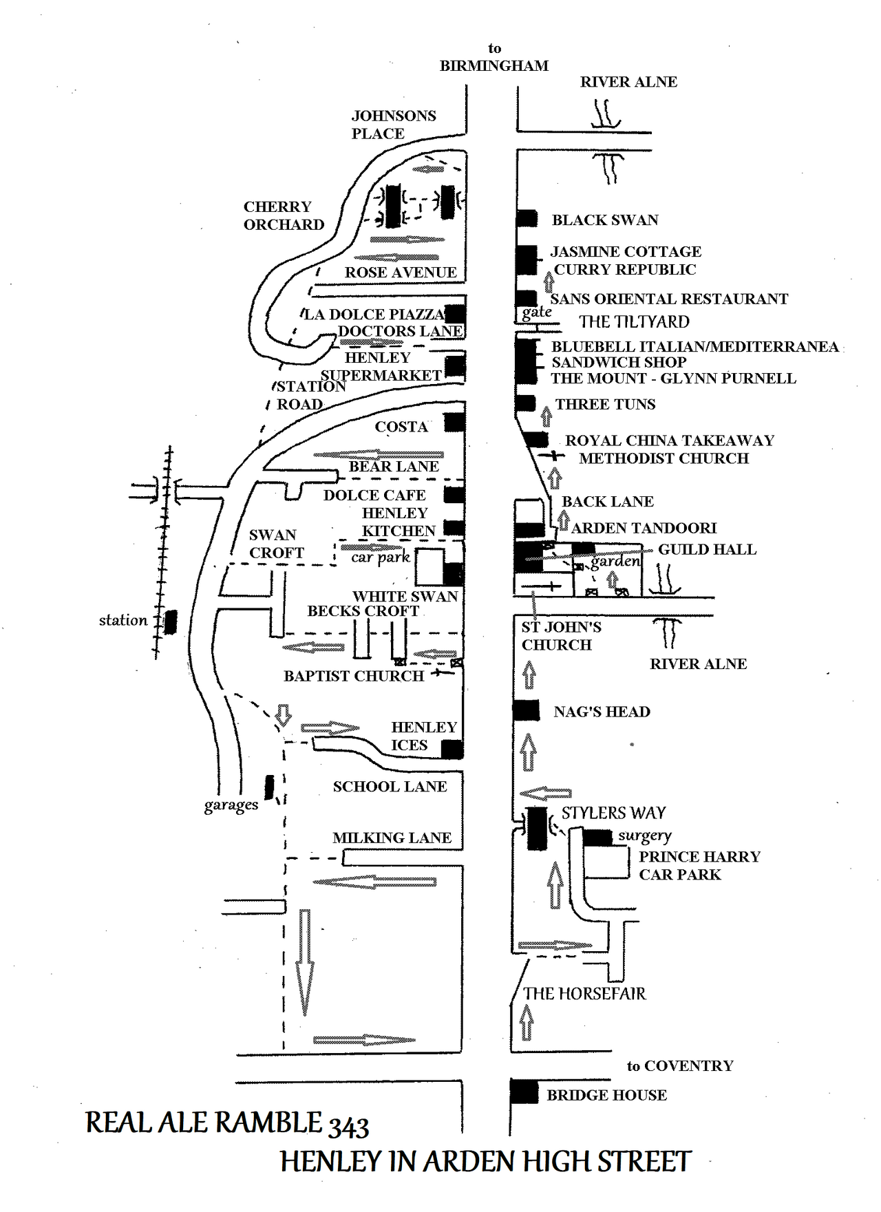
REAL ALE RAMBLE 342 Saturday April 12th
HENLEY IN ARDEN, THE CROFTS 2 miles and some pubs
The walking group are spending the weekend of April 11 – 14 in Henley in Arden. So I thought we could invite anyone who wants to join us for the day to come along on the Saturday..
Henley was a noted coaching town, the first stop south of Birmingham. The High Street was lined with innumerable inns and became known as the ‘Henley Mile’ because of its length. On the western side of the High Street these inns had burgage plots behind them and beyond that crofts for grazing, because of the number of horses involved in coaching. A number of paths from the High Street gave access to these crofts with a lane connected the rear of them all. This lay-out is not apparent on the eastern side of the street because of the proximity of the river and new housing development.
A few years ago we walked the maze of old lanes and paths called ‘Shuts’ in Shrewsbury. Similarly we can walk the old lanes in Henley that led from the High Street to the crofts behind. We start from the BLACK SWAN at the north end of High Street, meeting at 12 noon and starting out at 12.30. The first two paths are short and uninteresting but from Doctor’s Lane southwards the lanes contain old cottages and views of the town, as they go up and down from the rear lane, which is now mainly a footpath.
During our visits to the High Street we can pop into the shops and cafes etc and decide where we want to eat in the evening and on Sunday.
Finally we reach the main road at the south end of the town. This is where we turn back along the opposite side of the High Street. Where the building line veers away from the road is the southern end of the eastern carriageway, now called Back Lane. Here we follow Horsefair and then turn left into Stylers Way to return to the High Street. We can have a look at the church of St John before walking up Beaudesert Lane to enter the Jubilee (Riverside) Gardens. Today the River Alne is particularly unpolluted and one of the few Warwickshire rivers to host both dippers and otters. Then through Guildhall Garden we come to Back Lane, all that is left of the northern end of the eastern carriageway. From here we walk past numerous shops, cafes and restaurants to return to the BLACK SWAN.
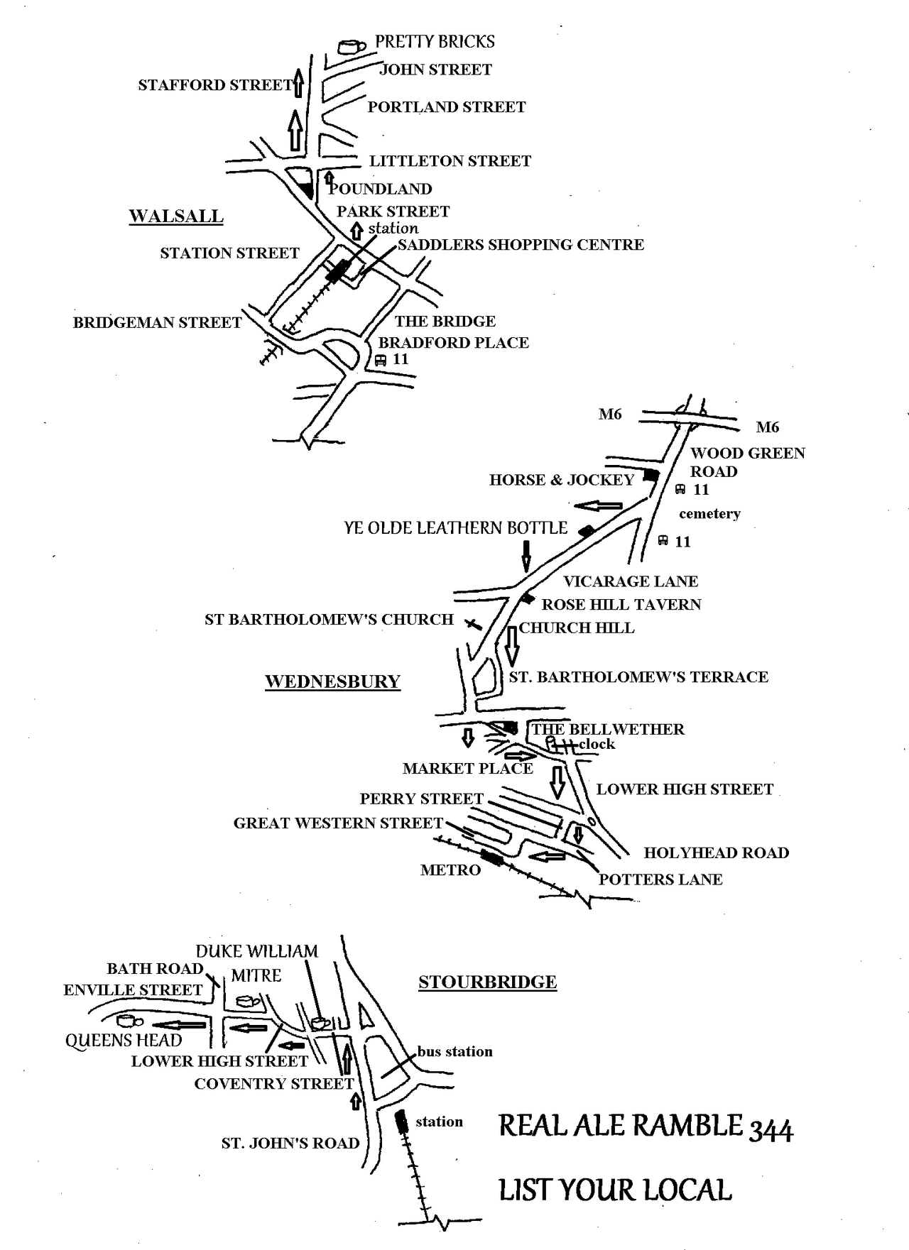
REAL ALE RAMBLE 344 Saturday May 10th
LIST YOUR LOCAL 1 mile in Walsall, 2 miles in Wednesbury, 1 mile in Stourbridge and 5 pubs
Following the tragic demise of the Crooked House in Himley in August 2023 the West Midlands Combined Authority (WMCA) and the Campaign for Real Ale (CAMRA) teamed up to review historic pubs throughout the region. The result was the ‘List Your Local’ campaign launched in September 2023. West Midlands residents were encouraged to nominate historically significant pubs in their area to the WMCA website. These were then examined with a view to applying for an ‘asset of community value’ status or the National Heritage List for England, administered by Historic England. By February 2024, 119 nominations had been received and of these five were put forward for listing. These five were the Pretty Bricks, Walsall; Ye Olde Leathern Bottle, Wednesbury; The Duke William, Stourbridge; The Mitre, Stourbridge and the Queen’s Head Inn, Stourbridge. Plenty there from Stourbridge then, but none from Coventry! I have allowed half an hour in each pub to appreciated the architectural wonders, and possibly a swift half pint as well!
Visiting these five pubs means criss-crossing the Birmingham conurbation, using a variety of modes of transport – for people my age you will need your WMCA ‘twirly’ pass, youngsters a daytripper ticket. We catch the 10.36 train from Coventry (platform 3) which arrives in Birmingham New Street (platform 3) at 10.56. The Walsall train leaves New Street (platform 4) art 11.15 and arrives in Walsall at 11.37. The platform numbers are those from my survey of this trip in March – they may well be different on the day!
Leaving the train at Walsall we can walk through Saddlers Shopping Centre or along Station Street, either way brings us to Park Street, where we go left. Then we fork right at Poundland and stroll slowly along Stafford Street to arrive at the PRETTY BRICKS for opening time. The real name of this pub is the New Inn, but it has a tiled exterior hence the popular name of ‘Pretty Bricks’. It is owned by the Black Country Brewery and it’s citation says:
‘Built in 1840, it was altered significantly in 1924 nut has remained relatively untouched since. It has a wonderful bar with stained glass screens on the lounge side and formidable kaleidoscopic carpets.’
After half an hour we do the 20 minutes return journey to the centre of Walsall, to Bradford Place to catch the No11 bus which runs from Walsall to Dudley (The 11A serves an estate and school). This leaves at 1.10. After passing under the M6 we see the Horse and Jockey pub on the right and the cemetery on the right. We alight here, there are stops on either side of Vicarage Lane. The scheduled time is 1.22 and a short walk will bring us to YE OLDE LEATHERN BOTTLE at about 1.30
‘Ye Olde Leathern Bottle dates from 1510 and boasts a beautiful timber-frame construction with a haunted snug’.
From here at 2.00 we do a bit of walking to cross Wednesbury to the Metro stop. We go right at the Rose Hill Tavern and pass St. Bartholomew’s church. Then we go down the hill at St. Bartholomew’s Terrace. Next we pass Wetherspoon’s (The Bellwether) and go through the Market Place, past the clock and through industrial areas to the tram route at 3.00 after an hour’s walk. As trams run every 10 – 12 minutes and it is a ten minute journey, we should be at The Hawthorns for 3.20 – ish. Here there is a train at 3.30 for Stourbridge, which arrives there at 3.57. Trains leave every 15 minutes.
At Stourbridge Junction we change to the cute little shuttle for Stourbridge Town station. From here we walk through the town, passing the Duke William and Mitre on our way to the QUEEN’S HEAD:
The Queen’s Head dates from 1862 and was once home to Edward Rutland’s brewery. It is another Black Country Ales pub and has low ceilings, bay windows and a cosy fireplace.’
Walking back into town we come to the MITRE again:
‘Founded as the Mitre Hotel in the early 1700’s, it was demolished for the road to be widened and rebuilt in 1934. Some features are thought to have been reused, such as the stained-glass windows and panelling. Also look for the moulded ceiling cornices, carved timber chimney-piece and side lamps with mitre-shaped fittings.
Lastly we come to the DUKE WILLIAM:
‘Built in 1820. It was the taproom for the North Worcestershire brewery, who brewed behind the pub. It was remodelled in 1903 with terracotta and glazed brickwork on the exterior. It was acquired by Wolverhampton and Dudley breweries (Banks’s) in 1914 and the brewery closed. However, it was purchased in 2009 by Craddock’s, with a new brewery being installed in 2011. Although the brewery has now moved elsewhere, it remains part of Craddock’s estate of five pubs.’
By now it should be around 5.30 or later and it is time to start our journey home, via Birmingham Snow Hill and a short walk to New Street, so we should be back between 6.30 and 7.00, although I have been quite generous with the timings, so possibly a little earlier.
SUNDAY LUNCH WALK 142 Sunday April 6th
BRANDON WOODS 3 miles, 1 pub & 1 cafe
COMMENTS: Some of the woodland paths can be muddy after rain
The re-opening of the Roseycombe has prompted me to repeat thus bluebell walk from last year, with variations. As we have done a few walks round the outside of these woods, this time I have planned a walk through the middle.
We meet at the ROSEYCOMBE on Rugby Road in Binley Woods. Hopefully the weather will be good enough to sit in the garden and admire the views over the fields and Old Lodge farm towards Brinbklow Road, whilst drinking Mad Goose or Taylor’s Landlord!
At 12.30 we set off along Rugby Road to the pedestrian crossing. Then we walk down Woodlands Road as far as the village shops. Here there is a bookshop-cum-general store, a farm shop that was closed when I was there and a Chinese takeaway amongst others. After the row of shops we go left and follow a road called ‘Court Leet’, with the woodland on our right. We soon come to Craven Avenue and the gate that gives access to the woods.
We take the path that leads straight on into the woods until we come to a T-junction by a pond. Turning right here we follow the path through the woodland, passing numerous benches and a second pond until eventually coming to a lone tree that stands in the middle of a junction of paths. We turn right here and cross a stream that feeds a distant, larger pond. Turning right again we follow a path with the edge of the woodland on our left and the stream on our right. Eventually we come to the gate that gives access to the park on our left.
We walk through to the CAFE IN THE PARK. Lets hope it is open and our Nepalese host is there! After suitable refreshment we walk up Birchwood Road to return to the ROSEYCOMBE.
Anyone fancy Sunday lunch?
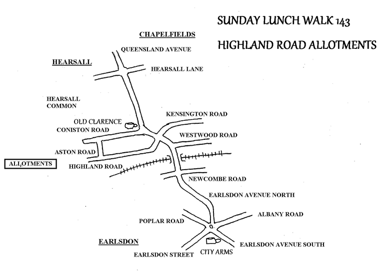
SUNDAY LUNCH WALK 143 Sunday May 4th
HIGHLAND ROAD ALLOTMENTS A few yards and 1 pub
Today we have very kindly been offered a stroll around the Highland Road allotments. I think it best to meet at the City Arms as everybody knows that and then take the short walk round to the allotments. We meet at 12 noon at the CITY ARMS and then at 12.30 stroll round to Highland Road for our guided tour.
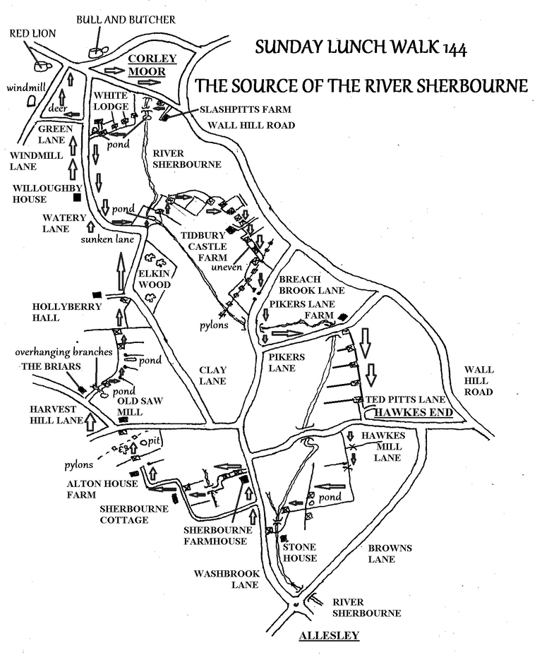
SUNDAY LUNCH WALK 144 Sunday June 8
SOURCE OF THE RIVER SHERBOURNE 6 miles & 2 pubs
COMMENTS: This is a proper country walk. It has uneven bits where you need to watch your footing plus low branches to limbo past!
I was asked some while ago to arrange walks to the sources of the Rivers Sherbourne and Sowe, so this month we have a walk from the source of the River Sherbourne almost as far as Allesley. At the great watershed of Corley Moor all the water that rises on the western slopes ultimately drains into the river Trent system, whilst all that on the east drains through the Sherbourne to the Avon and hence the Severn. This is an excellent lengthy country walk where in March Teddy and Freddy saw lots of buzzards and a deer.
We meet at 12 noon at the BULL AND BUTCHER in Corley Moor and walk back towards Brownshill Green along Wall Hill Lane. We go right into fields and pass the front of Slashpitts Farm. Here a trickle of a stream issues from the hedgerow alongside the road; this is the infant River Sherbourne. It flows through a pond here and continues southward, whilst our path takes us through fields to Watery Lane.
The lane becomes a deep, narrow sunken lane, so beware of traffic. When the lane turns 90 degrees right, we go left into fields and pass a second pond. This is another candidate for the source of the river as past Slashpitts Farm it runs underground before resurfacing here, except during exceptionally wet weather. Here Teddy and Freddy saw lots of buzzards.
Then we follow the eastern side of the valley, with the river below us. We pass Tidbury Castle farm. The next section of path is uneven, very lumpy and bumpy, so please be careful where you put your feet! After this we arrive at Breach Brook Farm.
Going south along this lane we cross the river before turning into Pikers Lane. Along here the little river runs alongside the roadway before passing under the lane. Now we go right into fields and follow the river on the valley side again. This path takes us to Hawkes End, where we cross the lane to enter more fields. Here we walk diagonally across the fields to arrive at a charming stretch of the river at Stone House.
We emerge onto Washbrook Lane, where we turn right, northwards, to begin our return journey. At Sherbourne Farmhouse we go left along a grassy track that takes us over a stream to Sherbourne Cottage on the driveway to Alton Hall Farm. When the drive turns sharp right we enter a field and follow the hedgerow to pass the farm. Across another field we come to a junction of lanes by the old Salmond’s saw mill. Following Harvest Hill Lane we take a pathway on the right just before The Briars. This takes us past a pond and under low, overhanging branches where a bit of limbo dancing is called for!
Through subsequent fields we come to the entrance to Hollyberry Hall, where we rejoin Watery Lane and pass through the sunken section again. Approaching Corley Moor we turn left along Green Lane. This takes us to Windmill Lane where Teddy and I came across a deer. Then we pass the windmill, now part of a house and then the RED LION for a well earned rest and some refreshment. After half an hour it is just a few yards back to the BULL AND BUTCHER
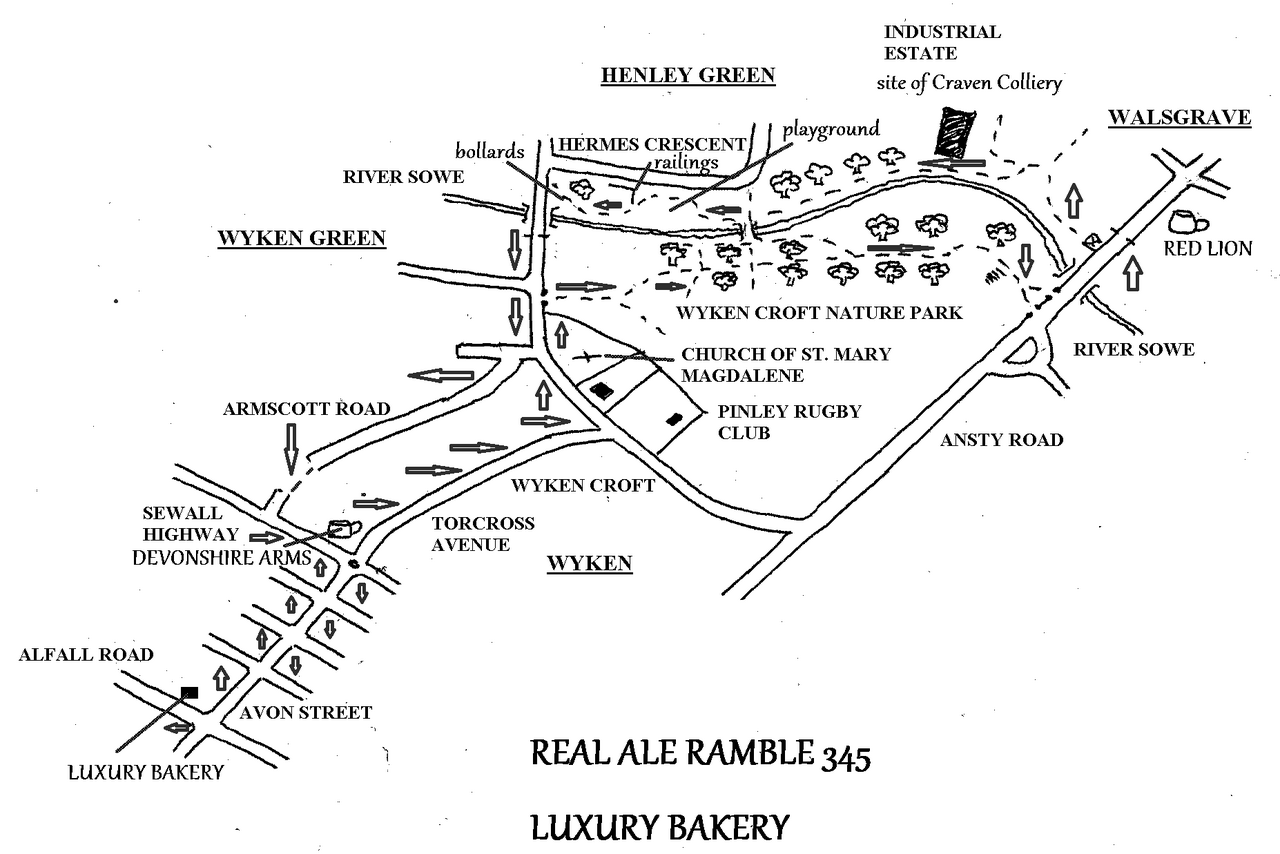
REAL ALE RAMBLE 345 Saturday June 14th
THE LUXURY BAKERY, WYKEN 4 miles and 2 pubs
Today we are combining pints and pies again, and also a little nostalgia as this is the area where I was born and where my grandparents lived.
We meet at 12 noon at the RED LION in Walsgrave. If you drive there don’t forget to enter your registration number in the machine on the bar.
At 12.30 we set off upstream along the right bank of the River Sowe. This takes us to Hermes Crescent and then Wyken Croft. We go left and then right into Armscott Road. At the end we go left and right along Avon Street. Up the hill we come to Alfall Road an the right, where we find the LUXURY BAKERY. Here is the nostalgia bit. I was born in Wyken and seventy years ago I used to accompany my grandmother to this bakery, where she would buy a half ounce of fresh yeast to make her own bread, and it is still there! Admittedly under new ownership, but it is still the same bakery. I don’t think they remember me !
From the bakery we return down the hill to the DEVONSHIRE ARMS on Sewall Highway, once a grand suburban boozer and at one time run by Martin McKeown, but it is now a ‘Sizzler’, so no doubt I will be forced to resort to a glass of wine!
Then we carry on along Torcross Avenue until we come to Wyken Croft at Pinley Rugby Club. This is the last place that I played, admittedly 35 years ago now. It is here that my right leg decided to tell me it was time to pack it in and take up gentler pursuits such as long distance walking! Next to the rugby club is the church of St Mary Magdalene, the oldest roofed building in Coventry, where my parents were married and are now interred, so please indulge me if I go for a wander around the grounds.
After this we enter Wyken Croft Nature Park. This is a large open space, created not so much because of any altruistic feelings on the part of the authorities, but because it was the site of the Coventry rubbish tip until the 1950’s and 60’s and so was incapable of being developed. Through the nature park we return to the RED LION.
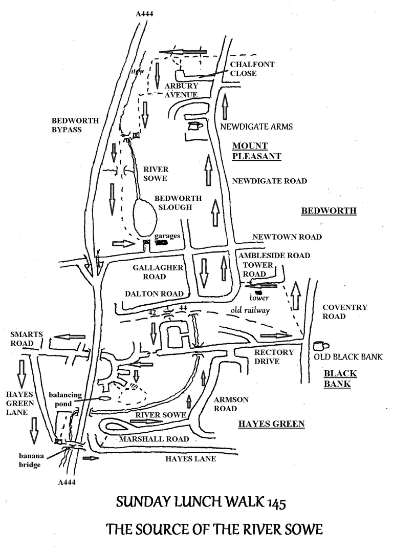
SUNDAY LUNCH WALK 145 Sunday July 6th
SOURCE OF THE RIVER SOWE 4 miles & 2 pubs
Having discovered the source of the Sherbourne last month, it is now the turn of the river Sowe.
This is a less green walk as the Sherbourne rises in countryside at Corley Moor whilst the Sowe rises in or near suburban Bedworth. The river is not easy to follow as it flows behind housing estates, or beneath them in a culvert. Bedworth appears to care even less for its river than Coventry does!
We meet at 12 noon at the NEWDIGATE ARMS on Newdigate Road, Bedworth. This was in the past a pleasant sduburban pub, lets hope it remains so. The Newdigates are the family that owns Arbury Hall and they were prominent local coal masters.
At 12.30 we set off north along Newdigate Road, past Chalfont Close to join the path that crosses the housing estate. This soon brings us to the Bedworth Bypass embankment, where we go left. Between the path and embankment is a ditch that is the source of the Sowe, although it was dry in May. Really the river rises in marshland on the opposite side of the Bypass, but that is inaccessible from here. On our right we pass the steps that lead across the Bypass, but you would have to be suicidal to try to cross the busy dual carriageway here! We follow the ditch, eventiually crossing it by a footbridge, where it becomes watered, and come to Bedworth Slough, the result of mining subsidence. The Slough is thought by many to be the source of the Sowe.
Past the Slough we come to Newtown Road, where we go left and right to enter Gallagher Road. Now we pass through a housing estate, which the river passes behind and is then culverted under. We take a path between Nos 42 and 44 Dalton Road and go under the old railway line, which may be familiar to some of you from a previous walk. Here the river re-emerges to flow under Rectory Drive. Now we pass through a very new estate, which contains a small riverside park, before passing under the Bypass to Smarts Road. The river also goes under the Bypass near here, so when we turn into Hayes Green Lane we return to the river. Again there is a small piece of riverside green, which does not connect to anywhere else. From here we cross the 'banana bridge' to Hayes Lane. On the left a path takes us to Marshall Road and then to Armson Road, which leads back to Rectory Drive. Here we go right, uphill, to the OLD BLACK BANK for a little refreshment.
After half an hour we start off again by taking the footpath from Coventry Road, which leads to Tower Road and past the old water tower, which is a prominent landmark throughout this walk. Then right into Ambleside Road and along Newdigate Road brings us back to the NEWDIGATE ARMS.
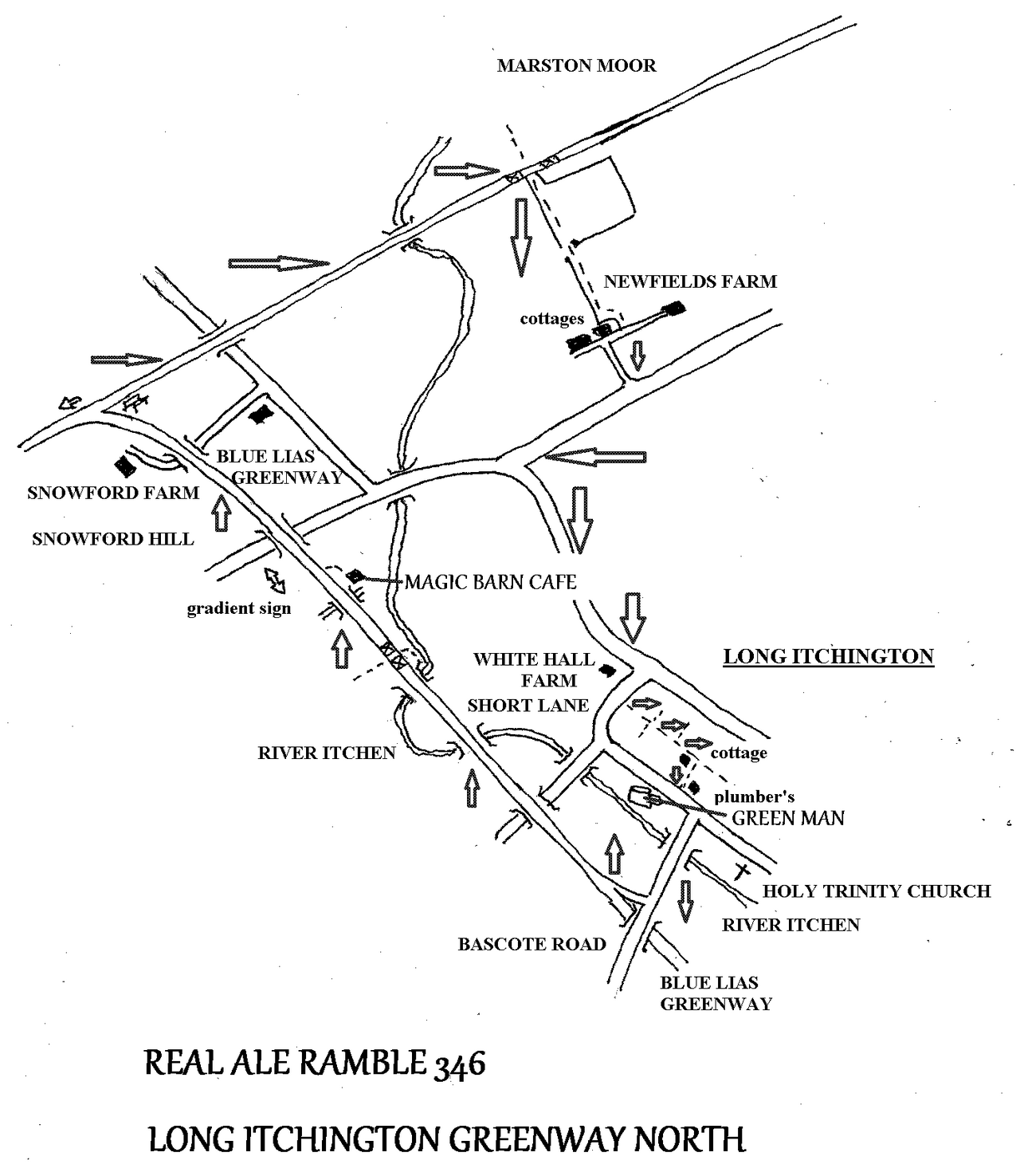
REAL ALE RAMBLE 346 Saturday July 12th
LONG ITCHINGTON GREENWAY NORTH 5 miles. 1 pub & 1 cafe
You may recall that we have visited the Blue Lias Greenway before, as it was being developed, to follow it south into the village and also to follow it a little way north. It is in fact part of the old railway route from Leamington to Daventry. Now that the bridge over the A423 at Marton has been re-instated it is time to follow the Greenway as far as we can towards Rugby, starting with this stage, from Long Itchington to Marton Moor
We meet at the GREEN MAN in Long Itchington at 12 noon and at 12.30 move off along Bascote Road to our first crossing of the River Itchen. A little further on we come to the Blue Lias Greenway. Over the few years it has existed it has become quite established and green. We cross the river again, twice, also lanes and tracks until we come to the MAGIC BARN CAFE. This is a new facility for the Greenway, a cafe stuck in a field, where the only likely customers are people travelling the Greenway. We can see what it is like.
Next we pass the only piece of railway architecture to have survived – a gradient sign. This tells us that we are climbing Snowford Hill at a challenging gradient of 1 in 80. Will we all make it to the top, I wonder? Shortly after Snowford Farm we come to the junction with the old main line. Main line? Leamington to Rugby that is (or was)..
We follow this greenway over a lane and then over the River Itchen yet again until a footpath crosses our route. Going right this path takes us along a field track to Newfields Farm. Then we follow lanes back to Long Itchington, so please be alert to traffic. Back at the village we turn right into Short Lane and take a path on the left. This path takes us by hidden routes through the midst of Long Itchington. We turn right at a cottage to emerge on the road by the GREEN MAN, alongside a ‘ghost’ sign for the village plumber.
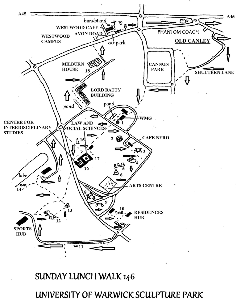
SUNDAY LUNCH WALK 146 Sunday Aug 3rd
UNIVERSITY OF WARWICK SCULPTURE PARK 4 miles & 1 pub
This time we have a walk round the Sculpture Park as instigated by Vanessa. Although the information leaflet lists 25 works, I have only found 19 due to sculptures disappearing (I am sure at least one has been stolen!), or being replaced, or in two cases being too far from the main body of the University (in the Gibbet Hill Campus and on the path to Kenilworth).
As usual when we visit the University we meet at the PHANTOM COACH on Fletchampstead Highway at 12 noon and set off at 12.30. We walk through old Canley village, along Shultern Lane and enter the University from Cannon Park.
My walk differs from the official version as we are starting from the Phantom Coach rather than the centre of the University, so I number the sculptures in a different order. My running order is in bold numerals, the official numbers follow in brackets and italics. So we come to No 1 (16) just past the WMG building. This is 'Around Zero' of 1988 by Michael Stallard. We will have already missed out their No (17), a work in wicker which I guess has succumbed to the ravages of time and weather. From here it is a short walk left and right to No 2 (6) 'Flayed Stone' of 1998 by Peter Randall-Page. Then continuing past Cafe Nero we come to a collection of works on the green in front of the Arts Centre. These are No 3 (5) 'Pollen Bomb', 2017 by Joanne Risley, No 4 (3) 'Forest', 2011 by Atsuo Okamoto, No 5 (4) 'Butterworth Bench', 2012 by Jim Partridge and Liz Walmsley and No 6 (1) 'White Koan', 1972 by Liliane Lijn. Then we enter the Arts Centre. Just inside the doors should be No 7 (2) 'Slab and Bar Relief' by Geoffrey Clarke, but this appears to have been replaced by 'Navigator', 1984 by Keir Smith.
Leaving the Arts Centre and crossing the road, past the bus stops, we come to No 8 (10) 'Days of Judgement (Cat 1)', 2012 by Laura Ford. When I first saw it I thought it was a mouse, but no, it is a most contemplative cat! This one I do like. Following on is No 9 (11) ‘Lets Not Be Stupid’, 1991 by Richard Deacon. Then behind some halls of residence we come to No 10 (12) ‘3B Series 1’, 1968 by Bernard Schottlander. From here we walk up the approach to the sports facilities and take the footpath to No 11 (18) ‘Black Cube’ 2013 by Lotte Thuenber. Near here used to stand ‘Big Takeaway’ by Tom Waugh, but that has gone. I seem to remember its being stolen. Rather a pity as I liked it, but now its empty plinth lies there like a fallen megalith.
Now we carry on along the road until we reach the Sports Centre, or as they call it the ‘Sports and Wellbeing Hub’. Here we turn right onto the path back to the Central Campus. After a few yards a grassy path leads into a field. Here roams No 12 (22) ‘The Good, The Bad’, 2007 by Jake and Dinos Chapman. It is two giant (life-sized?) dinosaurs that would look great in our back garden. We continue through the field and pass from the sublime to the ridiculous when we come upon a small onion-shaped object, No 13 (21) ‘Song’, 2017 by John Isherwood.
Next we walk down to the lake to find the rather underwhelming No 14 (23) ‘Reclining Stone’, 2017 by Guy Stevens. From here we follow the lakeside until we cross Gibbet Hill Road again to take a path to No 15 (9), the colourful ‘Needle of Knowledge Obelisk’, 1994 by Stefan Knapp. We continue along the path to the rather pompously named ‘Centre for Interdisciplinary Studies’ building. In the quadrangle here stands No 16 (8) ‘Grown in the Field’, 1976 by Avtarjeet Dhanjal. Next to this is the Law and Social Sciences building, which also has a quadrangle, containing No 17 (7) ‘Dark at Heart’, 1985 by Peter Randall-Page. Now we have finished all the works in the campus proper so we walk out past the Batty Building to Milburn House in the Science Park. Here stands No 18 (24), another colourful work entitled ‘Untitled’, 1989 by Allen Jones.
The final walk is from Milburn House, across Kirby Corner Road and second left into Avon Road to the Westwood Campus, or Teacher Training College as I remember it. Here we find No 19 (25) ‘Global Oracle’, 2015 by Alec Findlay.
By now being fully ‘cultured-out’ it is a short walk back to some real culture in the pub (Phantom Coach). Perhaps we can do the two far flung sculptures we have missed today on a future ramble.
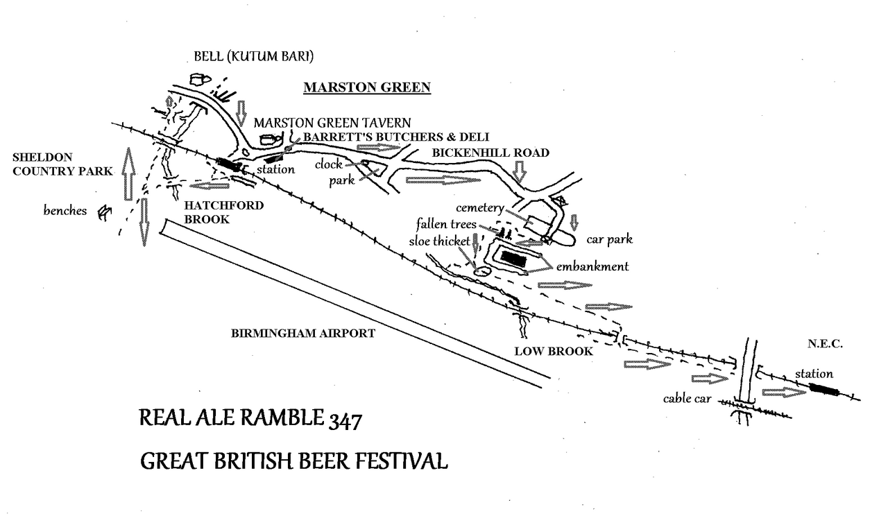
REAL ALE RAMBLE 347 Saturday August 9th
GREAT BRITISH BEER FESTIVAL 4 miles and 1 beer festival
COMMENTS:
9.36 train from Coventry station - AN UNUSUALLY EARLY START.
Tickets for the Great British Beer Festival are:
£ 6 for CAMRA members
£ 16 for non-members
£ 64 for a group ticket (5 people)
As the Great British Beer Festival is being held at the N.E.C. this year I thought it would be a good idea to combine it with a Real Ale Ramble and indulge two of my passions, real ale and country walking. This will mean an unusually early start for a Real Ale Ramble, so that we can get to the N.E.C. around opening time at 12 noon whilst there is still a reasonable choice of ales and before it gets really busy.
I have thoroughly enjoyed surveying this walk. There is a great contrast between the modernity of the airport and associated motorways, opposed to the bucolic village of Marston Green with its narrow lanes and fields, despite its being surrounded by the vast estate of Chelmsley Wood.
In order to get to Marston Green unfortunately these days you have to change at Birmingham International. So we catch the 9.36 Avanti train from Coventry to Birmingham International and change there to the 9.52 West Midlands train which takes just three minutes to reach the next station, Marston Green, at 9.55.
As soon as we alight from the train we walk straight into Sheldon Country Park, where, at the end of the runway there are a group of benches so we can watch the planes land and take off for five or ten minutes. After this we follow Hatchford Brook to the Bell, which appears to be an ethnic restaurant called Kutum Bari these days, and the road back to Marston Green. I have included two pubs on my map, not because I intend to visit them, but merely as landmarks. After all, why go to a pub when we are on our way to the biggest real ale pub in the world!
At Marston Green we pass Barrett’s Butchers and Deli, where you may want to purchase something. Then we carry on along Bickenhill Lane, past the clock and war memorial park on our right. Where the road makes a sharp turn left we take the access road to the cemetery. This road passes between the cemetery and its car park. It continues as a broad path around the cemetery, with an embankment on the left. Behind the embankment is Birmingham Business Park. Turning left around this embankment we pass through a sloe thicket before following the left bank of Low Brook and then the railway. Soon we cross the tracks via a bridge. Continuing to follow the railway, now on the opposite side, we reach Birmingham International station again, which gives access to the N.E.C.
Tickets for the Great British Beer Festival are:
£ 6 for CAMRA members
£ 16 for non-members
£ 64 for a group ticket (5 people)
After a couple of hours I imagine I will have had enough and be looking to catch a train home. Others may have different ideas!
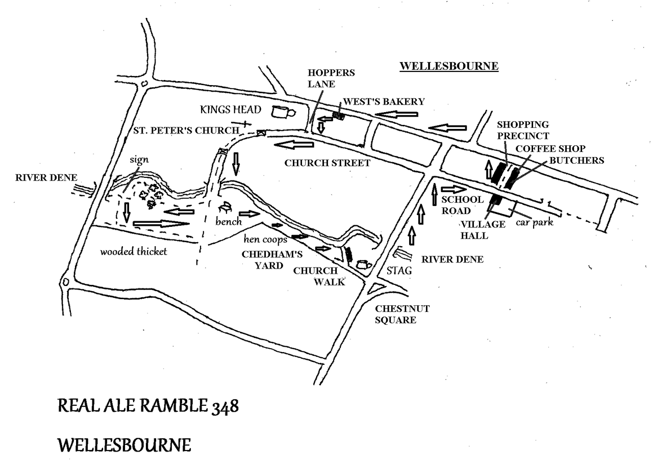
REAL ALE RAMBLE 348 Saturday September 27th
WELLESBOURNE 2 miles, 2 pubs and 1 cafe
There are two reasons for this walk: West’s Bakery, where we can purchase bread and cakes for a picnic; and Chedham’s Yard, which has a cafe. This walk will provide a number of opportunities for refreshment!
This village was Wallesburam in Anglo Saxon times and parliaments (witenagemot) were held here by Burgred, King of Mercia in 862 and 870. It was one royal manor until being split along the River Dene during the early medieval period with Wellesbourne Hastings held by Thomas Hasting and Wellesbourne Mountford held by Thurtstan de Mountford. The two villages were re-united in 1947 to form the Wellesbourne we know today.
We meet at the KINGS HEAD at 12 noon and at 12.30 go to West’s bakery to purchase bread and cakes. Then we go through the churchyard. The oldest parts of the church date from 1150. After crossing the ‘White Bridge’ over the River Dene there is a bench in grassland that will be ideal for our picnic. I will bring spread and cheddar. There will also be the opportunity for tea and cake at Chedham’s Yard!
After tidying up the picnic we take a short walk downstream to the bypass and then double back past the bench again. Now we follow the river upstream to Church Walk, passing some hen coops on the way. At Church Walk there is a varied assortment of old houses. Look out for ‘Mousehole’ which has a cat and mouse on the ridge of the thatch and next door there are two pheasants. Now we come to Chadham’s Yard.
Chadham’s Yard is a blacksmith’s and wheelwright’s workshop dating from the early 19th century. It fell into disuse in the 1960’s and was rediscovered and purchased by the Parish Council in 2002. It was entered in the BBC ‘Restoration Village’ competition in 2006 and won. The restored yard was opened to the public in 2012. The yard had been run by five generations of the Chadham family. Blacksmiths and wheelwrights tended to operate independently although the two trades were closely linked. Wheelwrights needed the blacksmiths skills to make and fit iron tyres to their wheels, but to have both in the same yard is unusual. We will be visiting the site on apple pressing day, so you should be able to add cider making to the other ancient skills you pick up! There is a cafe at the end of Chadham’s Yard.
After leaving the yard we continue along Church Walk to the STAG, an ancient thatched pub. We can take half an hour’s rest here and discuss our newly found skills. Then we follow the main road over the river before turning right into School Road. Here we come to the Village Hall and opposite the Shopping Precinct, a small area containing a coffee shop and butcher’s.
From here we turn left and follow another busy toad to pass the 18th century Talbot Inn, now apartments but I can remember it being open in the 1970’s. This takes us back past West’s bakery to the KINGS HEAD again.
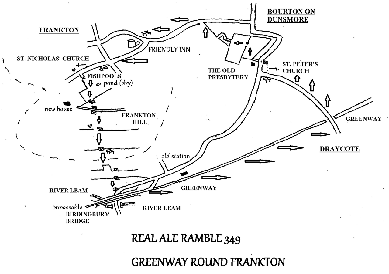
REAL ALE RAMBLE 349 Saturday October 25th
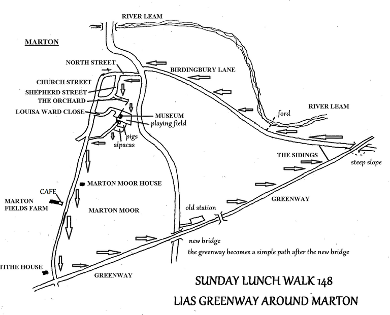
LIAS GREENWAY AROUND MARTON 4 miles & 1 cafe
-------------------------------------------------------------------------------
COMMENTS: There is a steep slope from the Greenway onto Birdingbury Lane
-------------------------------------------------------------------------------
Unfortunately the cafe at Marston does not open on a Sunday, so I have made this a Saturday walk. Its not a Real Ale Ramble as there are no pubs, but I don't really have any alternative. I can only excuse myself by stating that if this were 40 years ago there would have been two pubs to choose from – The Hare and Hounds (Ansells) and the Black Horse (Bass), both in Marton.
We meet at 12 noon at the village museum and playing field, which is at the end of Louisa Ward Close. At 12.30 we set off along a path that runs around the edger of the village. Here we pass small fields that contain miniuature pigs and alpacas. Then we take the lane through Marton Moor. This brings us to Marton Fields farm, which surprisingly for such an isolated place has a baby-goods shop and a cafe, where we can linger for a while looking out over fields.
After this we continue along the lane past Tithe House to the Greenway. We turn left along the Greenway until we reach the new bridge over the A423. After the bridge the tarmac ends and the Greenway reverts to being a simple footpath as it skirts the small industrial estate where Marton station used to stand. Along here in August I saw a flower that was new to me, a charming little yellow thing called ‘alkanet’.
We continue until we come to Birdingbury Lane, where we leave the Greenway. There is a steep slope down the embankment here, We pass another small industrial estate here called ‘The Sidings’ and then pass a ford through the River Leam before returning to Marton.
SUNDAY LUNCH WALK 147 Sunday August 31st
WHITLEY SOUTH COUNTRY PARK 3 miles & 1 pub
There are two new parks in Baginton: this one and Segro Park. Segro gets its odd name from the developers of the industrial estate on the south side of the airfield. However, when I surveyed this walk in July the gates to Segro Park were all locked and the paths fenced-off. There was no explanation why, perhaps the authorities thought it might escape! Whatever, there was no way of gaining access, so I shall have to leave that pleasure for next year and just do Whitley South Country Park for now.
We meet at the OAK in Baginton at 12 noon for a 12.30 start. We turn right out of the pub and walk through the wedge of open ground between two roads. Then we cross the village field to rejoin the road. We go right and follow Rowley Road for a short distance until we come to the car park. Then we walk the periphery of the country park. On the right we pass a pond where I saw both a heron and an egret in July. There are views of the traffic on the A45 and of the city in the distance from this vantage point. Eventually we circle back towards Rowley Road, but before we get to the road we come to a gate leading to the access track to the Lunt.
Then we go right and follow Coventry Road until coming to Holly Walk. This takes us to Hall Drive, which becomes a footpath at this point. The path takes us to St John the Baptist church and from there through the old village back to the OAK.
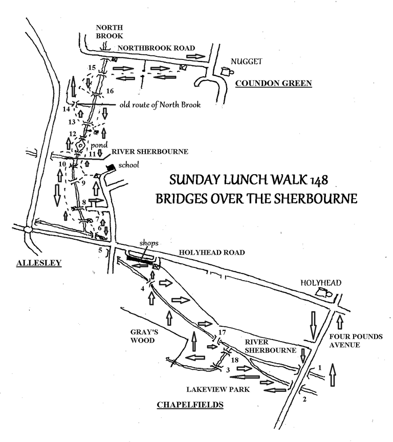
SUNDAY LUNCH WALK 148 Sunday Sunday October 5th
BRIDGES OVER THE SHERBOURNE 4 miles & 2 pubs
Walking through Coundon Wedge recently I noticed that yet another new footbridge has been installed. You might think that the authorities have got hold of a job-lot of bridges and had to find places for them all! This led me to wonder just how many cross the River Sherbourne and its tributaries in Coundon Wedge, so I counted 13 from Coundon Green to Four Pounds Avenue. This seemed a good theme for a ramble.
Having surveyed this walk I have had to revise my estimate up to 18. We cross most of them on the way out, leaving a few for the return journey.
We meet at the HOLYHEAD on Holyhead Road at 12 noon. Please be aware that the Holyhead now requires you to enter your registration at the bar. People may prefer to park at Morrisons, or in a back street, or catch the bus there. At 12.30 we set off along Four Pounds Avenue, a road with two bridges, one over the River Sherbourne and one over the mill stream that fed Spon End Mill. These bridges are not apparent on the road as they are level concrete structures.
Having crossed the first two bridges we enter Lakeview Park and pass the dry dirt scrapes that were meant to be ponds. We walk over to Bridge 3, which crosses a tributary stream of the Sherbourne as it emerges from Gray’s Wood. Then we follow the south bank of the river upstream to Bridge 4, which provides access to the shops on Holyhead Road. Across the junction here we come to the parapet of Bridge 5 giving views of the river.. Then we turn into Coundon Wedge by crossing Bridge 6 and walking through grassland to Bridge 7, which provides a view of the Jacobean Hotel and fields. Bridge 8 soon follows and we cross this into Newington Close. Now we have a short section of road walking before entering Coundon Wedge again and crossing Bridge 9, quickly followed by 10 where the North Brook separates from the River Sherbourne. We follow North Brook for a short while before coming to the pond, which has Bridge 11 at its downstream end and Bridge 12 at the upstream end. Then, entering fields, Bridge 13 is on our left. Crossing the field we come to Bridge 14 which spans a dry ditch, a former course of North Brook. Through more fields we reach the final bridge before Northbrook Road, No 15. From here it is a short walk up the hill to the NUGGET, where we can rest for half an hour.
On our return journey we retrace our steps to Bridge 15. Downstream of here is the latest new bridge, No 16. From here we follow the stream and river banks, past all the bridges we crossed previously, to Lakeview Park. This time we follow the northern bank of the Sherbourne before crossing Bridge 17, then 18 over the tributary, and over Bridges 1 and 2 on Four Pounds Avenue again.
Then the walk ends back at the HOLYHEAD.
SUNDAY LUNCH WALKS
These walks all start at 12 noon. Copies of these walks can be obtained from Beer Gonzo in Earlsdon, or for more details contact moc.liamg@ttekculfg>
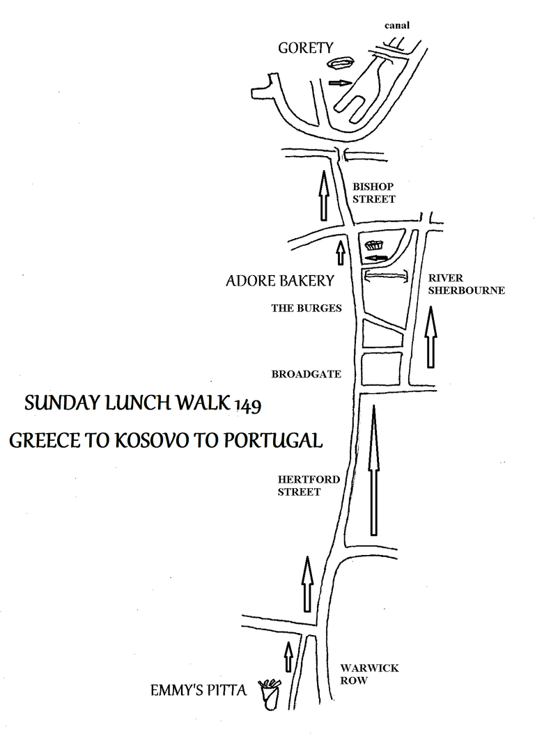
SUNDAY LUNCH WALK 149 Sunday November 2nd
GREECE TO KOSOVO TO PORTUGAL 2 miles & 3 cafes
Yes, its that time of year again. Well, sort of. In previous years I have done this walk in January, but I thought this time we could do it in November so that people could stock up on Portuguese sardines, pasteis, or Greek gyros kebabs for Christmas!
As usual we meet at EMMY’S PIITA at 12 noon and move off at 12.30, suitably stuffed with kebabs. We walk up Hertford Street and through Broadgate.
Then we take Trinity Street and Palmer Lane to check whether the spectacular riverside terrace has been completed yet.
After this we come to ADORE bakery where we can spend half an hour before continuing up Bishop Street to Gorety’s to check out the Portuguese experience.
REAL ALE RAMBLE 350 Saturday November 22nd
SAM GAMGEE’S BIRMINGHAM 6 1/2 miles & 3 or 4 Pubs
This is one of our longer walks. Some of you may remember a year ago we visited the Physician in Edgbaston as I wanted to ride the tram to its western terminus at Edgbaston Village. While we were there I picked up a pamphlet on a walk they recommend around the area. The pamphlet claims the walk is 5 1/2 miles but I measured it as 6 1/2 with all my deviations and explorations. The truth is probably somewhere in between.
Why have I used the name Sam Gamgee? Because in 1957 No36 Harbourne Road, now the Physician, became the home of the Birmingham Medical Institute (BMI), where medics could meet and share knowledge. There was an extensive library with 12,000 volumes. In 2005 the library was named ‘The Sampson Gamgee Library for the History of Medicine’. The BMI and library later moved on and No36 Harbourne Road became the Physician. Sampson Gamgee was the distinguished Victorian surgeon Joseph Sampson Gamgee, who practised in Birmingham and invented a surgical dressing, which became known colloquially as a ‘gamgee’, a term that is still used occasionally today. A later resident of Edgbaston, J. R. R. Tolkien, used the name Sam Gamgee for a character in The Lord of the Rings.
We catch the 11.15 train from Coventry station which arrives ion Birmingham at 11.44. The we have a short walk to the CRAVEN ARMS in Gough Street for opening at 12 noon. We leave at 12.30 and set off through a shopping precinct called ‘The Cube’ next to the Mailbox, to gain access to the canal. We do the longest part of the walk first by taking the towpath on the right side of the canal southwards. After passing through the tunnel, which is illuminated, we come to a footbridge that leads to Birmingham University. Through the university grounds we come to Church Road, where we go left to cross the tunnel. At St. George’s church we turn left into Highfield Road. The PHYSICIAN is along here on the right.
After half an hour’s rest and relaxation we continue along Highfield Road and cross Broad Street. We go between the Plough and Harrow Hotel and the Birmingham Oratory. We pass to the rear of the Oratory, which has the following full name:
The Oratory of St. Philip
Catholic Church of the Immaculate Conception
National Shrine of the Blessed John Henry Newman
Quite a title! We continue straight on and pass the tower called ‘Perrot’s Folly’. It was built by John Perrot of Belbroughton, but no one is sure why. From 1884 to 1979 it was a weather observatory but is now disused.
Soon after Harold Road starts on the right, where there are some Severn Trent Water premises. Then we turn left into Reservoir Road. Soon we are on banks of Edgbaston Reservoir. This is a canal feeder reservoir, although with the Severn Trent premises so near it is possible that they take some water too. We go left and walk half way round. We pass the rowing club, whilst the boat club is at the opposite end, but in October the water was so low I don’t think anyone would be doing much rowing or boating. We pass the Birmingham Settlement, which is an eco-site demonstrating what can be done in the fight against climate change. There is a cafe here.
Then we cross a bridge over a feeder stream, turn left and climb a flight of steps. We cross a road and walk along Selwyn Road to enter Summerfield Park. We follow the right-hand edge of the park and when we leave it use a pedestrian crossing. Here there is a path to Northbrook Street, where we take a flight of steps down to the canal and go right.
The canal we follow now is the Birmingham New Line, which was a straight canal that cut across the route of the meandering Old Main Line. The old canal thus formed loops that became branch canals. Thomas Telford was appointed chief engineer of the new canal in 1824 and it opened in 1827 as a broad canal with towpaths on both sides. This shows the threat of the railways even at such an early date. The Liverpool and Manchester Railway was first surveyed in 1822, the company formed in 1826 and the line opened in 1830. The Stockton and Darlington Railway opened in 1825 and the Birmingham and Liverpool Railway was proposed in 1826, although not opened until ten years later. This early railway enthusiasm seems to have encouraged the canal company to improve the Birmingham canals to speed up carriage. The Oxford canal through Warwickshire was also straightened between 1829 and 1834.
We pass numerous bridges and old canals until we come to the DISTILLERY at the Roundhouse on the opposite bank. I have never visited here, in fact I never knew it existed until I saw it in October, so we have to go and investigate. After 30 minutes we continue for a short distance before coming to SOMMAR BREWERY AND TAPROOM. It seems that this business has closed, bit we will have to check it out. Then we continue along the canal to the junction with a signpost in the middle. We turn right towards Worcester. This takes us past Gas Street Basin and under Black Sabbath Bridge at Broad Street, back to the Mailbox and the Cube and hence to the CRAVEN ARMS.
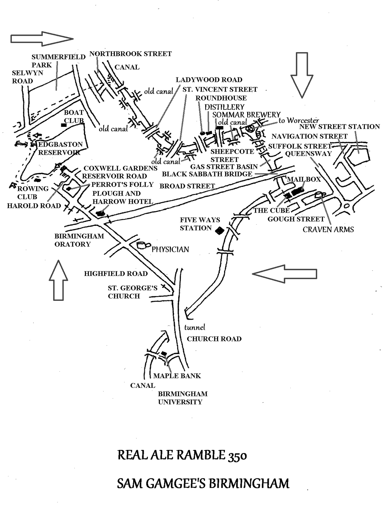
REAL ALE RAMBLE 351 Saturday December 13th
KENILWORTH HAS A WETHERSPOONS! 2 miles & 4 Pubs
As well as wanting to visit the new Wetherspoons in Kenilworth, I thought a short walk through Kenilworth would be an ideal event for the festive season. Although it is only just over a mile from the Dictum of Kenilworth to the Queen and Castle and just under a mile back, this walk has plenty of variety and interest.
We meet at 12 noon at the DICTUM OF KENILWORTH, the new Wetherspoons pub. It might be a good idea to make the short journey from Coventry by train – they are hourly and the 12.00 arrives at 12.06: it is then a short walk through the shopping area to the Dictum.
At 12.30 we set off to walk just around the corner to the ALE ROOMS, a micropub in an old shop premises. Then at 1.00 we walk along Borrowell Lane passing the Old Schoolhouse with its charming plaque and then a well (spring). Next we cross a bridge over a brook and turn left into a gravel access road. In a short distance this becomes a footpath that follows an outer defensive ditch of the castle. The ditch curves round and the path joins a track leading to the castle car park. Here we take a path on the left, down some steps and around the outside of the castle walls. As we approach Purlieu Cottage we take a right-hand fork which brings us out at Castle Green where the QUEEN AND CASTLE stands.
After half an hour here we set off again, heading for the ford. Then we follow the brook through Abbey Fields as far as the swimming pool, which is still not finished. Here we turn right and climb the slope back into the town. Now we can visit the ALMANACK before returning to the DICTUM
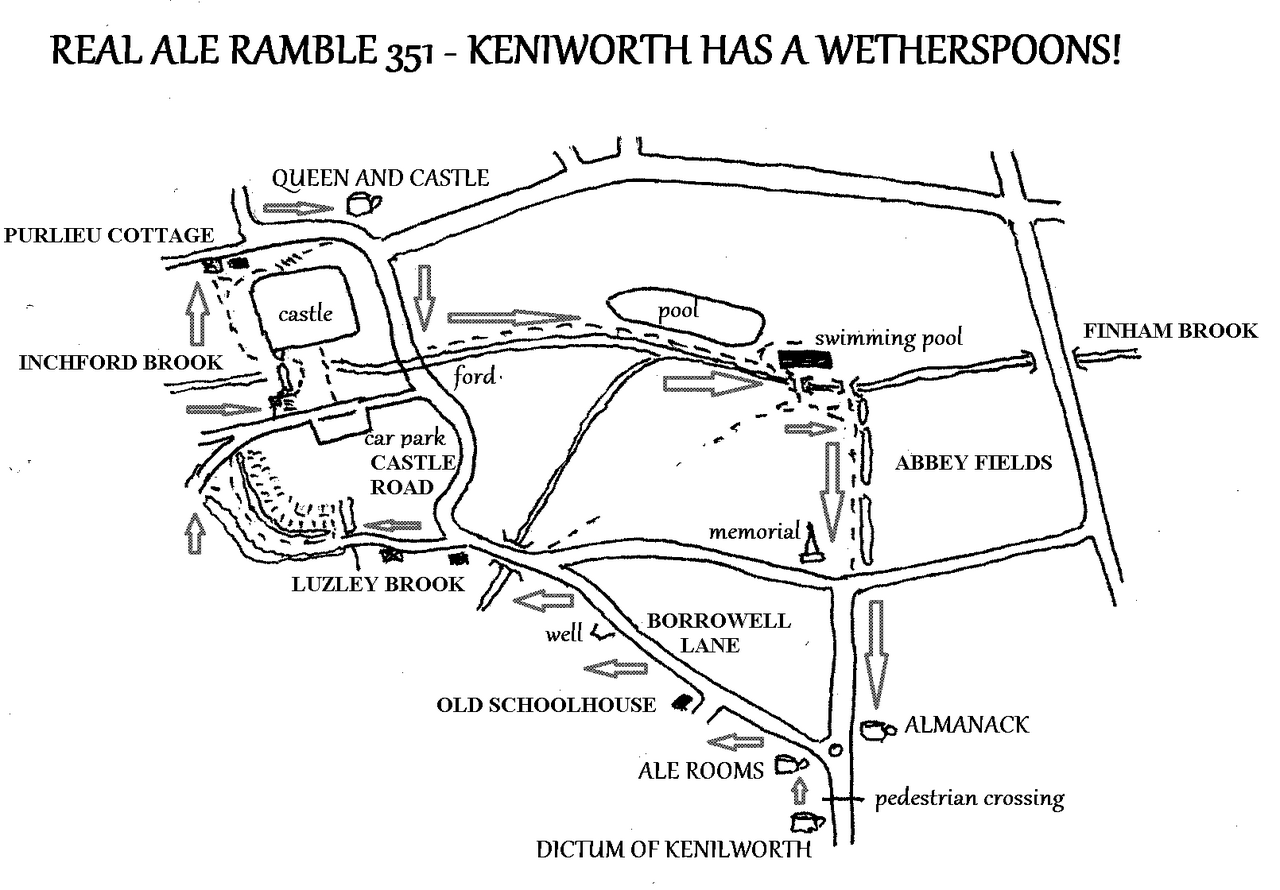
SUNDAY LUNCH WALK 151 Sunday November 2nd
TWISTED PLAYWRIGHTS 2 miles & 3 cafes
Some time ago Marianne questioned why we didn’t start a walk from Playwrights rather than always using Gorety’s at the canal basin. So, always willing to oblige, here we go!
We meet at 12 noon at PLAYWRIGHTS CAFE in the canal basin. I found this walk fascinating for its historical aspect, both industrial, medieval and modern. At 12.30 we set off along the canal walking north from the basin, past Electric Wharf, through the old Courtaulds site and under Foleshill Road. The we pass the site of Webster’s brickworks on our left and pass under Stoney Stanton Road. After this we continue along the canal with the old Admiralty factory on the left bank. We turn into Freehold Street, which was developed by the Freehold Land Society, as were the original streets of Earlsdon. Half way along we pass the old Coventry City Supporters’ Club, now the EAV Centre, whatever one of those is. At the end of the street we pass the old Freemason’s Tavern, now the Jalalabad Mosque. We cross the road here and follow a footpath which passes St. Mary and St. Benedict’s School before crossing Berry Street. We continue to follow a path between housing to emerge onto Vauxhall Street near the old Vauxhall Tavern, now student accommodation.
We next cross a small grassed area towards the old Brewer and Baker, also student accommodation today. Then along South Street we pass Southfields School to arrive at the crossing of Sky Blue Way. This will take us to Far Gosford Street and TWISTED BARREL.
After half an hour’s rest and recuperation the return journey is somewhat shorter. We walk down Far Gosford Street towards town and cross the road at the second pedestrian crossing. Then we follow a path alongside the remains of the city wall under the ring road system. We walk under the elephant building and then past Pool Meadow.
Next we go through Lady Herbert’s garden, passing the two remaining city gates. Alongside the ring road we come to the footbridge leading back to the canal basin, where we return to PLAYWRIGHTS.
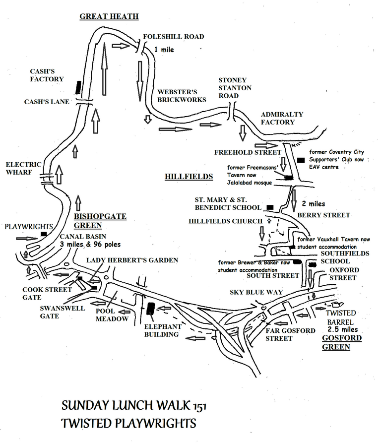
REAL ALE RAMBLE 352 Saturday January 17th
COVENTRY'S GOOD BEER GUIDE PUBS Many miles & 12 Pubs
Once again it is time for our annual trip to all the Good Beer Guide pubs in the city. Coventry City play Leicester at home on this date, so we should be alright for Byatt’s. As usual we meet at the GREYHOUND in Sutton Strop.
Buses leave Trinity Street frequently – the 11.23 No20 arrives in Longford at 11.42 and then it is a short walk along the canal to Sutton Stop.
From the Greyhound, we go to Byatt’s, then Twisted Barrel.
After that, we work our way into the city centre, stopping off at all the GBG pubs on the way to the Hops D'Amour.
We then catch the X1 bus from Belgrade Theatre to Allesley at 18, 38, 58 past the hour. Even I don’t want to walk out to Allesley and back for just one pub! The X1 returns from Allesley Post Office at 07, 27 and 47 past the hour. Alight at Four Pounds Avenue.
We visit the two GBG pubs in that area, and then make our way to the final pub - The City Arms in Earlsdon.